List of Authors
>>About this blog
Recent blog post
|
[yaz]
February 16, 2019 09:00
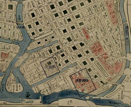
I was in charge of a guide for "Ningyocho-Higashinihombashi" in the training of a certain guide club, and as a guide for the "Tsukiji" and "Ningyocho" districts, I investigated the interest of Asakusa Mido.
Tsukiji Nishi Honganji Temple is the reconstruction of Nishi Honganji Temple in Asakusa Hamacho, which was destroyed by the great fire of the Meiryaku era. Asakusa Mido, the original Nishi Honganji Temple, was founded in Asakusa Hamacho in March 1621. The location is the back of Machiya, 2-chome, Yokoyamacho. In Kanei 2 (1625), the Shogunate officially recognized as a separate hospital and became "Nishi Honganji Temple". It is also known as "Edo Seaside Gobo" or "Hamacho Gobo".
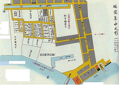
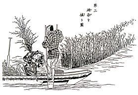
If you refer to the Edosho map of Bushu Toyoshima-gun, you can see Asakusa Gobo on the east side, just north of Hamacho moat behind Motoyoshihara. (Refer to the cut-out picture below.)
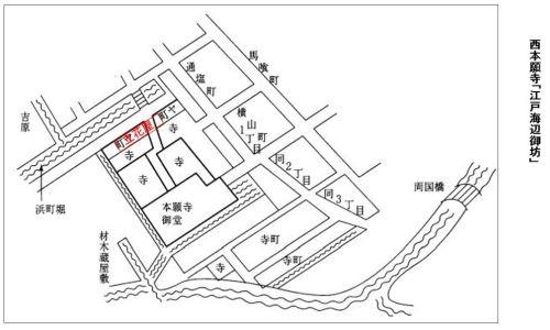
There was a small townhouse on the moat side of Hamacho, branch temple, main hall. It is said that "Tachibana" was sold here, and there is a theory that it was later named "Tachibana-cho".
 There are 57 branch temples on the premises, Mido's size was 12 spaces (width) X8 spaces (depth), and the direct burial ground on the left side of Mido was 58 tsubo. It is said that the size of Nishi Honganji Temple would have been 20,000 to 30,000 tsubo, given by Matsudaira Echizen Mamoru in the Meiryaku era. There are 57 branch temples on the premises, Mido's size was 12 spaces (width) X8 spaces (depth), and the direct burial ground on the left side of Mido was 58 tsubo. It is said that the size of Nishi Honganji Temple would have been 20,000 to 30,000 tsubo, given by Matsudaira Echizen Mamoru in the Meiryaku era.
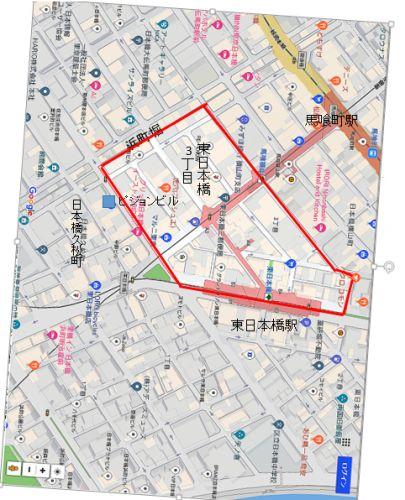
The part facing Hamacho moat will be Tachibana-cho later. Tachibana-cho is said to be "Higashibashi 3-chome" on the current map. The area surrounded by the red frame is Higashi Nihonbashi 3-chome.
After the great fire of the Meiryaku era, Higashi Honganji Temple moved to Asakusa Sanjusangen-do Temple and Nishi Honganji Temple moved to Hatchobori Tsukiji Temple "Umiai". After the relocation, Nishi Honganji Temple follows a strange fate.
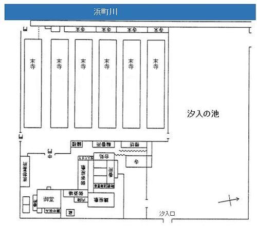
After the relocation of the temple due to the great fire of the Meiryaku era, Terachi was taken up, and the traces of Nishi Honganji Temple and Asakusa Mido were given to Matsudaira Echizen Mamoru of the Fukui Domain, which has strong connection with Junyo, on May 14 of the same year. You. There were 13,000 tsubo. With this in mind, the surrounding area gradually changed its appearance, and on the east side of Matsudaira Echizen Moriyashiki, the land of the Shogunate officials and lent it to townspeople, became a town area, `` Dobo-cho '' (Doho-cho) was born, and the moat drawn behind Asakusa Mido became Yagenbori, and the Yonezo of this area was set up in the Yonezo area, where the salary of the whole area. In the south of the mansion, there is a small town, Muramatsucho, and further south is a samurai residence. Let's refer to "Enpo era Nakanogata" (upper figure) in the Chuo-ku history book. At the location of Nishi Honganji Temple, the ambiguous expression "Yokoyamacho 2-chome South Machiya Ura" is generally made, but if you look at this material, you can nodd it.
Reference:
1) Chuo-ku History Chart
2) Takashi Shiraishi: "Nihonbashi Tachibana-cho Commercial History Memorandum of Understanding - Wholesalers and Town-"
(Mita Business Research, Vol. 41, No. 6, February 1999)
3) Tokyo Famous Places
[yaz]
January 20, 2019 09:00
The current Yaesu-dori is a landfill of the Momiji River, which was dug as a canal for transporting materials for the construction of Edo Castle in Keicho 17 (1612). Ten canals (Funairi moat) were dug on the coastline between the Edobashi Junction on the Metropolitan Expressway and the Kyobashi ramp. Eight of these were reclaimed in Genroku 3 (1690). The canal of Yaesu Street (Momiji River) connected to outer moat between Kaji Bridge and Gofuku Bridge. During the Enpo era (1673-80), the western half of the area, that is, Chuo-dori, the Momiji River (west side) on the outer moat side was reclaimed, and in 1774, the area from Kyobashi Intersection to Kuyasu Bridge (east side of the Momiji River) was reclaimed.
A picture showing the cityscape of Nakahashi Hirokoji appears at the Edo Famous Zoukai. Two roads (Chuo-dori and a right-angle road) are drawn, which one is Chuo-dori? You can guess that the road running from right to left is probably "Chuo-dori", can you decide?
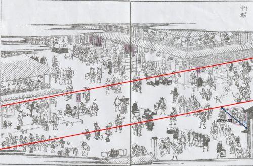
There are many townspeople on the thick road, so I guess they are walking around the commercial areas of Ginza in Nihonbashi. The samurai and their servants are walking along the road that crosses from the upper left to the lower right, but they probably head to the castle. If this guess is "positive", the road going left and right is Chuo-dori. Let's analyze whether the guess based on this situation evidence is correct.
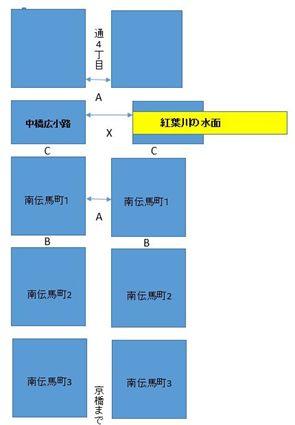
Looking at the oldest existing gu ticket map, the width of Tooricho (currently a block along Chuo-dori) was as shown in the figure below.
A = Countryside 10 B = Kyoma 6 C = Yokocho / Shindo Kyoma 3-4 (1 between Kyoma and 1 between Edo and 1.83m)
According to the "Hoei era 7 Tiger Year (Minami Temmacho Figure), the east side of Nakahashi Hirokoji Temple is only down between Chuo-dori and "X-A". After understanding this, let's take a look at the Edo famous place map. If you connect the eaves of the cityscape presumed to be Chuo-dori to the north and south (red line), it will be (red line), and you can see that the east side is decreasing in number as expected. From this consideration, it can be seen that the road leading to the left and right of the famous place is "Chuo-dori". I don't know how many X is.
[yaz]
December 17, 2018 18:00
"What are you talking about?" I feel like I can hear a voice. Hibiya is decided to be Hibiya, where Hibiya Park is located. But near Hatchobori Takahashi, there is Hibiya Shrine and Hibiya Riverside.
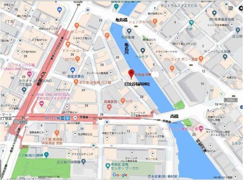
The origin of Hibiya Inari Shrine was that when Michio Ota built Chiyoda Castle in the first year of Choroku (1457) in the Muromachi period, he was grateful for the blessings of heaven and earth and worshiped at Hibiya Park. When Ieyasu Tokugawa entered the prefecture, a major expansion of Edo Castle began, and Hibiya Gomon was built and was kicked out. As an alternative site, it was transferred to the current Higashi-Shimbashi 2-1 near the intersection of Loop Route 2 and Daiichi Keihin.
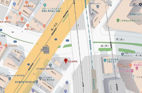
However, since the worshipers of Inari would be in trouble if they were not enshrined on the coast, they buried the tidal flats of Hatchobori, built shrine hall, and moved to their current location.
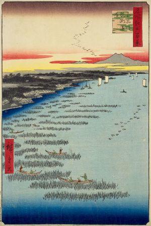
Hibiya was a Hibiya inlet, and was setting up a "fin" and picking up glue. One of the things that have been used since ancient times is a seaweed savory made from branches and bamboos, such as "kashi" and "nara", which have many twigs. In the 1710s, lobes began to be built to actively grow seaweed. One piece of Ando Hiroshige's "Hundred Famous Views of Edo" (1856-57) "Minamishinagawa Samezu Coast" depicts a stunning landscape of a seaweed farm.
This solves the mystery of Hibiya in Hatchobori.
[yaz]
Nov. 14, 2018 18:00
On November 10, 2018, a total of eight members of the Chuo-ku Tourism Association correspondent and the volunteer guide group "Tokyo City Guide Club" to which I belong, climbed the Edo Castle Ishigaki quarry "Usami no Nakoyama". Was. (This is scheduled to be reported in January as the third installment.)
After the descent, Anjin Miura (William Adams) near Ito Station visited "Anjin Memorial Park", which is said to have built a Western-style ship.
Anjin received a mansion in Edo Nihonbashi, with the daughter of village headman Magome Kageyu in Nihonbashiodenmacho as his wife, and has a strong connection with Nihonbashi, Joseph and Susanna. In 1598, he headed to Orient with Jan Jooss Ten on the Leafde and drifted to Usuki City, Oita Prefecture with 24 crew members. Ieyasu Tokugawa highly evaluated Anjin Miura's ability and recruited him as a political and diplomatic adviser. In addition to the residence in Nihonbashi, he was treated with a territory of 250 stones to Hemi Village, Miura Peninsula. The name of Anjin is based on the fact that the pilot was called Anjin at that time.
From 1604 to 11, at the order of Ieyasu, the head of the Uraga Navy, Shogen Mukai, a ship carpenter and Adams used a ship carpenter from Ito to build Japan's first Western-style sailing ship at the mouth of the Matsukawa River (the junction of the Karato River). We built 80 tons and surveyed the coast on this ship.
The place considered to be a shipyard is near the Anjin Memorial Park.


I stood with my friends in a place presumed to be a shipyard. It's a frank impression that it's smaller than I imagined.
After that, under the order of Ieyasu again, he built 120 tons of large ships that could go into the open sea, and in 1610, he lent the 120 tons of ships to Bibello, the governor of Ispania (Spain), and crossed the Pacific Ocean to Acapulko (Mexican) via the United States.


In order to commemorate the launch of the construction of a Western-style sailing ship, Ito City holds an Anjin Festival every year on August 10 and holds a large fireworks display. I went to see it last year, but it was a great crowd.
[yaz]
October 30, 2018 14:00
"Nihonbashi Ebisu Kotora City" is held on October 19 / 20 every year around Takarada Ebisu Shrine, the former Otemmacho (Nihonbashi Honmachi 3-chome, Otemmacho) and Horidome-cho, centered on the former Otemmacho Shrine. You. It has already been finished, but a friend was open, so I was able to visit and have a good time.
"Bedarazuke" comes from the fact that radish is pickled with sweeteners such as koji and sugar, so it comes from sticking to clothes, and once a young man said, "It's sticky, sticky." It is said that he was swinging the radish tied to the rope while shouting, and attaching it to the sleeves of the worshiper's kimono. In a sense, you may have used it for a "marriage hunting" tool, right?
I would like to talk about the name "Kusaichi" before it was called Betara City.
The 27th volume of "Morisada Manga" written in the late Edo period began in "Edo Dai Temmacho Rotichi on October 19". If you read the inside, "It is also good to sell fresh pickled radish, so-called pickled radish, pickled dried radish with salt and bran, and add kedashi koji. Selling it to a night market, etc., only this night (this good person) is limited. " The special product may have "koji", but it seems that it was not included in the popular product.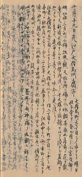
"Betara-shi" should be limited to 19 days, but why was it two days on 19/20?
Note: Moritaman's late manuscript, Morisadaman, is a book that explains the story of the three capitals of the Edo period (Edo Kyoto and Osaka). The author is Morisada Kitagawa. It began to be written in 1837 (Tenpo 8), and has been writing for about 30 years, and has been writing for a total of 35 volumes (30 volumes of "Presentation", 5 volumes of "After Collection"). Although it was not published and left as a manuscript, it was reprinted in the Meiji era, but it has been regarded as a basic document of the history of modern customs by 1600 appendixes and detailed explanations.
[yaz]
18:00 on October 1, 2018
The previous month reported on the story of Odawara-cho in Edo Nihonbashi, following the stone wall of Edo Castle's Ishichoba archeological site. I thought I had to actually climb, so I contacted the Ito City Tourism Association and climbed with the support of guides. . I will describe the struggle. (Road without Road, one side valley (Note): Naturally, there is no fence) road, climbing up and down the road along the rope, etc., so climbing alone without a guide is very dangerous.)
Date and time: 9:00 Set on June 27, 2018
Meeting place: Usami Station on the Ito Line
Weather: Sunny, 31°C/24°C
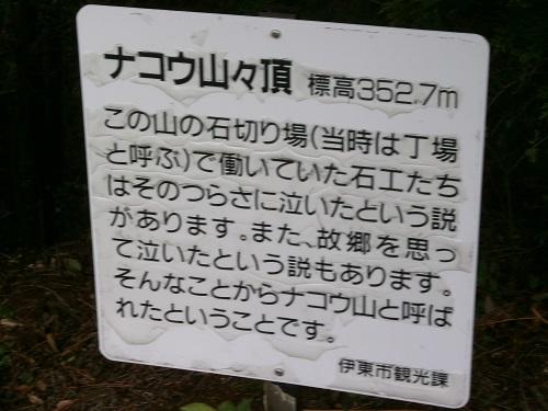
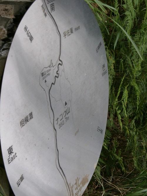
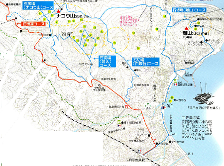
Departing at the scheduled time, as shown in the map below, go through the stone quarry (Mt. Nako) course, see "Ecchunokami Hashiba Ishiba" at the top, and go down the stone quarry (Shiranamidai) course. However, there was an accident in which the companion lost his wallet on the way to climb the wallet and had to return to the same course for search. It was a trip to see the national historic site twice (although it was out of breath).

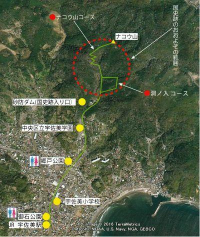
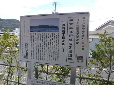
Departing from Usami Station, the party departs after grabbing the whole picture with the explanation board of Ishichoba beside the station! ! !! !! ! We will first aim at Godo Park, which displays stones found in the Donoiri area.

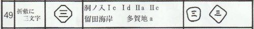
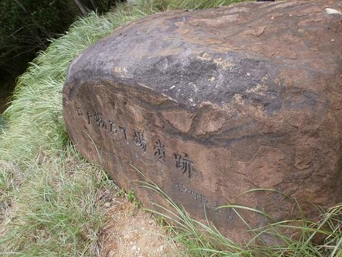
In the "Donoiri" area, which we are aiming for in the future, a series of steps such as "digging stones", "breaking stones", "shaping stones", "engraving stones", "accumulation of completed stones", etc. Archaeological sites showing the process are concentrated. The above-mentioned castle stone was found near the sabo dam in the cave entrance area, and is stored and released in Godo Park near the cave entrance area. The engraving is called "three characters on Orishiki", and it can be seen that the Inaba family of Usuki in Kyushu uses the same engraving at Osaka Castle.
Next, head to Usami Gakuen, Chuo Ward (545 Usami, Ito City, Shizuoka Prefecture). Previously, it was close to Usami Station, but moved to the foot of Nako. From this school, head to the "Edojo Ishichoba Ruins Hiking Course". (I didn't know that I would continue along the road without roads, so I started climbing vigorously.) Even if I started climbing and regret it later. The stone written as "Edo Castle Ishichoba Ruins" written by the 18th head of the Tokugawa family, Tsunetaka Tokugawa, was visible on the left, but I can't pay attention.

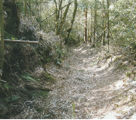
The road going up along the rope (Cliff?) A narrow road with a valley on one side (difficult if it falls) continues. You can't afford to walk on such a road, so you can't take a photo. I can't go up gradually.
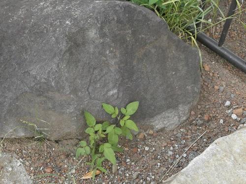
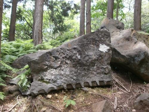
The next photo probably seems to be the path of pulling stones at that time. This "stone pulling road" seems to have continued in a shape that was dug down from the surrounding ground through the side of the area considered to be the work place. Stones like the photo are rolling on the side, upward and downward of the road without road.

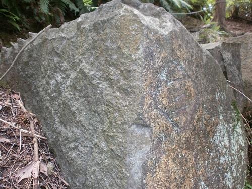
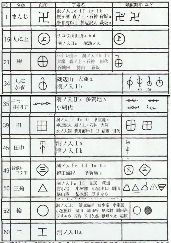
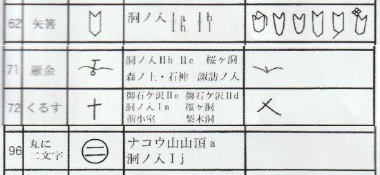
There are countless stones engraved with various marks, such as those that seem to be the seal of the daimyo family and those that do not know what the mark is. Some may be a sign of a mason who worked at work. According to a survey by the Ito City Board of Education, more than 30 types have been found so far. A list of the characteristics of the stone stamp found at Mt. Nako and Donoiri climbed this time is listed. There are interesting engravings such as "Manji", "On the top", "Mitsukushi Dango", and "Yahazu". "Three characters in Orishiki" is also contained.

There are countless "arrow hole stones" that remain after the "arrow hole" that broke the stone. Special skills are required to use natural stones dug out from the soil for the stone walls of Edo Castle. We use the nature of the stone to break it as we wish.
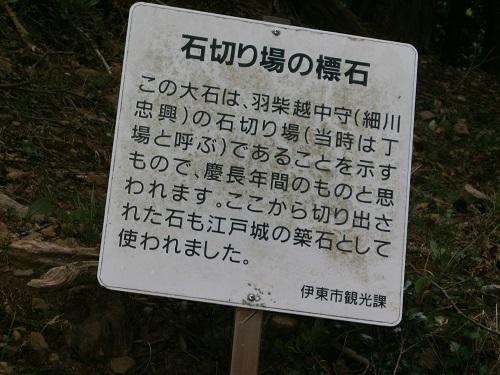
When I climbed, I finally arrived at the top around 12:00. It is a stone quarry of "Ecchunokami Hashiba (Tadaoki Hosokawa)". About 1 hour for lunch and break. The wind is strong and you can't stand at the top. (Because there are no convenience stores or shops, you need to bring a lunch box.)
A companion from Tokyo began to say, "I dropped my wallet," so I changed my schedule to return via Hakunamidai in a hurry and decided to return on the outbound route. (Because no people came into such a mountain, my wallet was found safely.)
I was tired on the outbound route, and the downhill was also hard. While rolling 4 to 5 times, he returned to Edo Castle Ishichoba archeological site. Take a commemorative photo.
The left and right in the back row of the photo are guides of the Ito City Tourism Association, and I have a cane. The guide leader couldn't see the exhaustion and lent me a cane, so I managed to go downhill. There is plenty of room for a guide in Ito City!

Arrival at Usami Station 14:30 Dissolution
[Reflection]
When going to a guide with such climbing, I felt that the following points should be noted:
1) Don't bring a heavy object like a single-lens reflex camera. Even rucksacks are a burden when climbing. → It is dangerous if you do not concentrate on climbing and descending, so it is impossible to shoot with a large camera, so there is no point to bring it.
2) The jeans are not suitable because they clung around when the legs are raised during the sweat season. I feel more tired.
We hope that you will look at the blog and be interested in climbing the "Edo Castle Ishigaki Ishichoba Ruins".
We plan to try again in early November, but considering the results of this trial, it will be about half of the climbing we reported this time so that I can participate softly.
|
Links
|


