Chuo-ku Tourism Association Official Blog

Chuo-ku Tourism Association correspondent blog

Introducing Chuo-ku's seasonal information by sightseeing volunteer members who passed the Chuo-ku Tourism Association's Chuo-ku Tourism Certification and registered as correspondents.

List of Authors

>>About this blog

Recent blog post

The sidewalk in Chuo-ku is interesting! 13 [Kabuto-cho, Kayabacho]

[Minato kid] August 22, 2018 09:00

Hello, this is Minato kid.

Today, I came to the sidewalks of Nihonbashikabutocho and Kayabacho.
 

♪ Welcome to the sidewalk museum!
 
kayaba01m.JPG

At the foot of the bus stop at Kayabacho 1-chome, I found a picture of Toden.

The Toden in the picture seems to be 19 lines.

It was the route from Dori Sanchome to Oji Station.

In addition, there are many systems that pass through Kayabacho, and it seems that it was a key point of transportation at that time.
 

It goes back to 1903 that a tram began running in Tokyo.

Time changed, and in the 1940s and 1940s, the transportation network from Toden to subway changed drastically.

kayaba02m.JPG

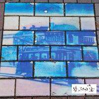
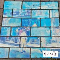
There was also a picture of Toden on the sidewalk on the Kabuto-cho side.

I wonder if this is dusk. The sky dyed indigo is beautiful.

Well, let's walk towards Armor Bridge.
 
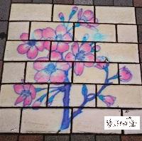
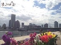
I found two pictures of flowers.
In this area, there is a street called Ueki Nagaya.
On the fair, there was a market selling plants and bonsai.

kayaba03m.JPG

 
kayaba06m.JPG
 
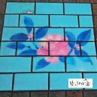
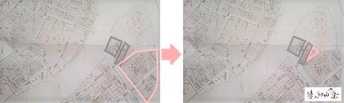
Kabuto-cho and Kayabacho are towns surrounded by three rivers.
Nihonbashi River, Kaede River and Kamejima River.
During the Edo period, there were many unloading sites and warehouses along the river.
 

kayaba04m.JPG
 
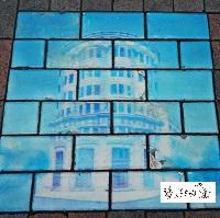
In 1872, Eiichi Shibusawa, the father of modern capitalism, set up a residence in Kabuto-cho and founded Daiichi National Bank and Tokyo Stock Exchange.

The five-story tower building that resembles the central keep in the distance is the Daiichi National Bank.

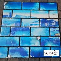
Well, it's the sidewalk in front of the Tokyo Stock Exchange.
 
kayaba05m.JPG
 
It was in 1931 that the cylindrical main building was completed.

A doris-style order column, a statue representing commerce, engineering, agriculture, and transportation, was placed at the top.

In the rear, there was a market hall. The ceiling was a majestic space with a skylight fitted with stained glass in a pale color.

In 1988, it was rebuilt into the current building.
 

The sidewalk with pictures is interesting, isn't it?

I feel like I can see the expression of the town.

From now on, I would like to walk in Chuo-ku, cherishing the encounter with wonderful sidewalks.

 
Correspondent Minato kid, Chuo-ku Tourism Association

sign200.png

No. 20 August 19, 2018


The sidewalk in Chuo-ku is interesting! 11 [Continue Tsukuda 1-2-chome]

[Minato kid] August 9, 2018 09:00

When you walk along Tsukuda Island, you often encounter a triangular space.

The sidewalk is also triangular to follow it.

The reason why a triangular space was created is in the direction of the streets.
 

♪ Tsukuda Island and Shin-Tsukuda Island

Looking at the map, the streets of Tsukuda Island are almost aligned with the Edo side, while Shin-Tsukuda Island is facing the same direction as Tsukishima.

A long time ago, fishermen in Tsukuda-mura, Nishinari-gun, Settsu-kuni (now Nishiyodogawa-ku, Osaka Prefecture) were invited by Ieyasu to enter Edo and served to offer white fish. Later, in 1644 (1644), Tsukuda Island was built.

At that time, Tsukuda Island was built facing Edo Castle. Therefore, Tsukuda Island seems to be in line with the town of Edo.

 
On the other hand, Shin-Tsukuda Island was born in 1896 (1896). It is reclaimed at the same time as the Tsukishima area, and the direction is the same as Tsukiji and Fukagawa. Indeed, there is Aioi Bridge between Fukagawa, which is connected by a straight road.
That's why a triangular space was created.

sankaku01re.jpg

I surrounded Tsukuda Island with a black line.

On the left, the red frame is Shin-Tsukuda Island. Right, a triangular space formed between them.

(Created based on the appendix map of the Chuo Ward Kyobashi Library "News from Local Room" / 1911)


♪ Tsukuda Island and Tsukuda-ohashi Bridge

sankakutukoo.jpg◀ Tsukuda-ohashi Bridge in Spring

Opened in 1964 (1964)

The orbits of Tsukuda-ohashi Bridge and Shingetsu Overpass also seem to make triangles.
Tsukuda-ohashi Bridge has changed its track significantly after crossing the Sumida River. It's because the direction of the road or the town is different.


The triangular space is a park.

A town with a history is interesting because it has expressions on the terrain and roads.

I really like Chuo-ku, where there are new discoveries every time I walk.


Chuo-ku Tourism correspondent Minatokko-chan

sign200.png

No. 18 June 22, 2018


1