Chuo-ku Tourism Association Official Blog

Chuo-ku Tourism Association correspondent blog

Introducing Chuo-ku's seasonal information by sightseeing volunteer members who passed the Chuo-ku Tourism Association's Chuo-ku Tourism Certification and registered as correspondents.

List of Authors

>>About this blog

Recent blog post

Exploration of alleys in Nihonbashi Muromachi and Honmachi

[often slap] May 31, 2018 12:00

Hello! Today, I would like to introduce some of the alleys that remain in Nihonbashi Muromachi.


Speaking of Nihonbashi Muromachi, I think the image of "Chuo-dori" is strong.
sbt_1805_001.JPG
This is the main street representing Edo and Tokyo since the Edo period.
Nihonbashi Mitsukoshi Main Store and Mitsui Main Building (both nationally designated important cultural properties), various long-established stores, etc.
Recently, many local antenna shops are also highlighting.


When you enter the east side from this "Chuo-dori"
There are many old alleys left from Nihonbashi Muromachi 1-chome to Nihonbashi Honmachi 1-chome.

sbt_1805_map.jpg

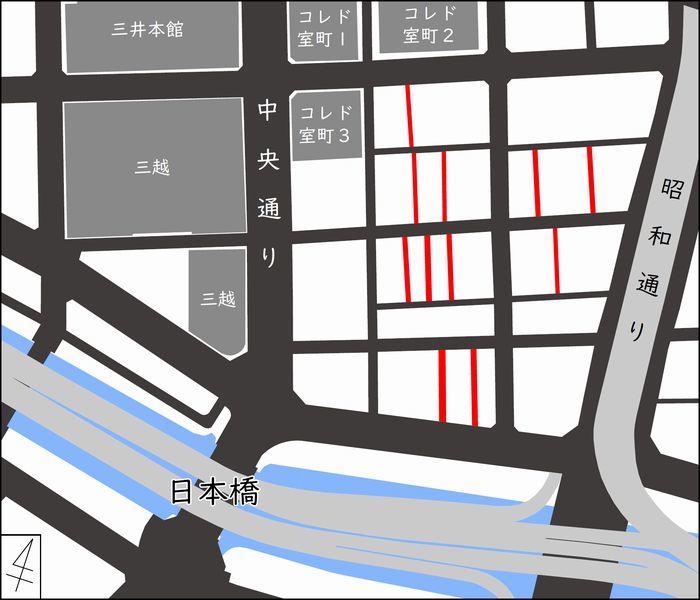
(In preparing this map, with the approval of the Geospatial Information Authority of Japan, we used basic map information issued by the House. (Approval No. 30, No. 225)

The road colored red on the map above becomes the alley.

In many areas of Chuo-ku, reconstruction projects after the Great Kanto Earthquake have developed wide streets and plots, which are the basis of the current city.

If the inside of the block was made up of small houses, a narrow alley (private road) was drawn into the site and it seemed to be an access route to each.

It seems that the urban structure of Edo townspeople's land was in the form of entering an alley from the shops facing the main street and connecting to a back tenement house.

In a sense, the same structure may have been handed down during the modernization of reconstruction after the earthquake.

After that, despite changes in various situations such as war disasters, high economic growth, and recent urban regeneration, they still remain.


sbt_1805_002.JPG
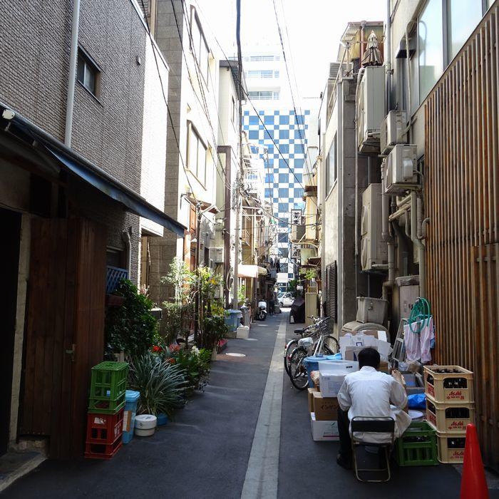
It is one of the alleys of Muromachi. Instead of Chuo-dori, it has a cityscape with a sense of life.


sbt_1805_003.JPG
Where the main street is rebuilt into a building, it feels as if you were exploring in the dark.


sbt_1805_004.JPG
There are many places where plants are placed at the eaves, which delights the eyes.


sbt_1805_005.JPG

It's a little maniac point of view....

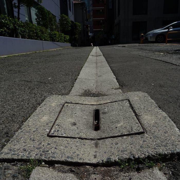
One of the characteristics of the alleys around Nihonbashi is that the drain is located in the middle of the road.

On general roads, drains are provided on both sides of the road, taking into account the passage of vehicles.

Here, the middle of the road becomes a hollow, and water gathers.

It is said that Edo had a sewerage system that drains rainwater and domestic wastewater from that time.

In the alley between the tenement houses, the waterway was flowing in the middle of the road.

Perhaps the drainage ditch in the alleys of Nihonbashi can be said to be a remnant of the sewerage system in the Edo period.


sbt_1805_006.JPG
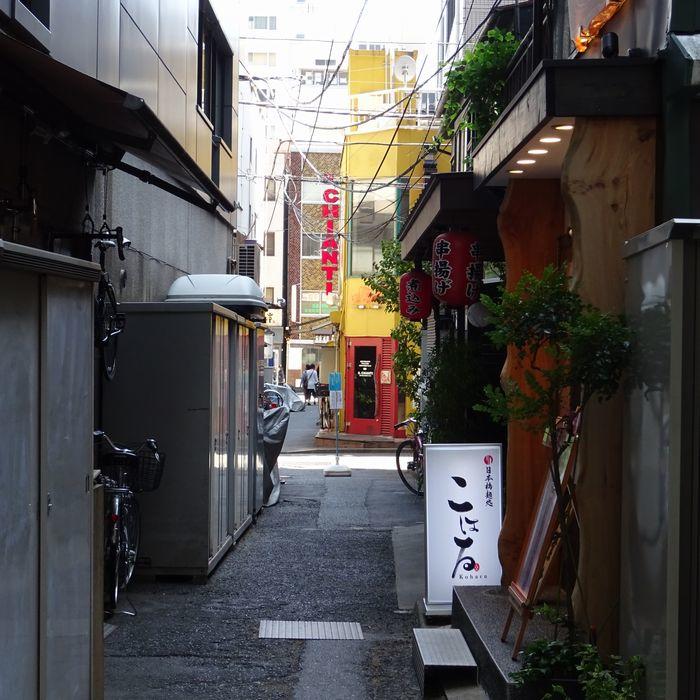
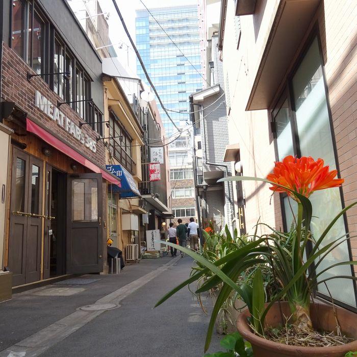
Along many alleys, there are various stores, mainly restaurants.
I'm looking forward to finding a hidden famous store.

 
sbt_1805_007.JPG

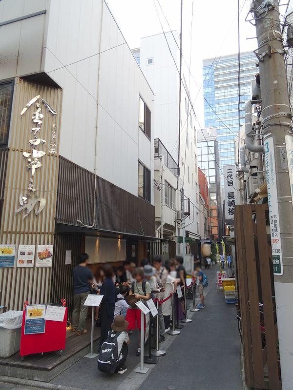
Some of them are always lined up, such as "Kanenosuke Kaneko" in the photo.


In writing this article, I walked through the alleys of Muromachi 1-chome to Honmachi 1-chome.

It is also attractive that each alley has a different atmosphere.

I was able to enjoy Nihonbashi even more deeply.


Reference:

・Ichiro Kobayashi (2014) "Walking along the alley with Yokocho"

"Edo Sewer" (Kodaira City homepage)


Chuo-ku (Nihonbashi River, Kanda River, Sumida River) from the top of the river

[often slap] May 2, 2018 18:00

Hello. My name is Shibata, who will be a sightseeing correspondent in Chuo-ku from this April.
Today, I would like to introduce "Chuo-ku from the top of the river"!

This time, during the photo session of "Kanda River Cruise Photo Session & Review Meeting 2018", which was held on April 21 at Aiei Gallery in Nihonbashikodenmacho, going with Professor Takahiro Ohara while enjoying the nature and culture of the city, I was on a cruise around Nihonbashi River, Kanda River, and Sumida River.
I would like to introduce the scenery of Chuo-ku (including on the boundary) from the photos I took on the day.

The route is like the map below. (I'm sorry for the miscellaneous map...)
It is a counterclockwise route that goes up the Nihonbashi River, goes down the Kanda River and the Sumida River, and goes up the Nihonbashi River again.
sbt_1804_map.jpg

sbt_1804_06295.JPG
The start/goal of this event is the Nihonbashi Departure and Departure located near the Nomura Securities Headquarters under the Nabashi and Nihonbashi.

sbt_1804_06041.JPG
This time, I got on the boat "Shitamachi Exploration Cruise Gareon" with a parlor here.
Goldfish is drawn on the roof, but some of them were genuine goldfish.

sbt_1804_06051.JPG
I'm going to go upstream.
It is a privilege unique to a ship to be able to take a picture of Nihonbashi at the angle looking up and pass under Nihonbashi.

sbt_1804_06064.JPG
By the way...This blackened part seems to be the scars of the fire associated with the Great Kanto Earthquake.
Nihonbashi today has been active for more than 100 years since it was replaced in the Meiji era, but it shows the length of its history.

By the way, pass through Nihonbashi and pass through Nishikawabashi Bridge and Tokiwa Bridge, you will see the bridge under construction.

sbt_1804_06075.JPG
This is Jobanbashi, the oldest stone bridge in Tokyo, which was rebuilt in 1877.
It was damaged in Great East Japan Earthquake in 2011 and is currently undergoing restoration work.

sbt_1804_06088.JPG
The stones used for bridges are kept at different locations along the Nihonbashi River after numbering them on each one. It is said that it will be restructured in the future.

After Joban Bridge, pass through Shin-Tokiwa Bridge and JR lines, and the section where the Nihonbashi River flows through Chuo-ku ends.

After this, the boat goes up the Nihonbashi River, reaches the junction with the Kanda River, and then descends the Kanda River.
The section where the Kanda River borders Chuo-ku is only about 500m downstream from "Saemon Bridge" to join the Sumida River ...
This section is very nice.

sbt_1804_06208.JPG
In the middle is Asakusabashi, the left is Taito Ward, and the right side of the photo is Chuo-ku, but in this area there are houseboat lodgings on both banks of the river, and you can see the scenery of houseboats lined up. I can do it.

If you pass through Yanagibashi while looking at the houseboat, you will go to the Sumida River next.

sbt_1804_06243.JPG
When you go out to the wide Sumida River, you can open your view at once.
On the way, you can also see the scenery of the Tokyo Sky Tree coming out of the middle of Kiyosu Bridge (a nationally designated important cultural property).
By the way, do you know the magnitude of the waves in front of Kiyosu Bridge?
Compared to the Nihonbashi River and Kanda River, the Sumida River has a larger wave, and it is quite thrilling when facing a small boat.
We go down the Sumida River while thinking that the boating of the Sumida River, which was popular during the Edo period, was quite difficult.

sbt_1804_06251.JPG
These are "Eitai Bridge" (nationally designated important cultural property) and "Okawabata River City 21" in Tsukuda. The competition between modern bridges and modern cityscapes is a highlight.

sbt_1804_06256.JPG
In front of Eitai Bridge, the boat turns right and enters the Nihonbashi River again. The first time you enter the Nihonbashi River is Toyomi Bridge (Kumin Tangible Cultural Property), a valuable "Fee Ren Dale-style bridge" in the shape of a ladder defeat.

As you go up the Nihonbashi River, the Metropolitan Expressway joins overhead again and approaches the center of the Nihonbashi area.

sbt_1804_06272.JPG
This is the famous Tokyo Stock Exchange Main Building. It is said that there is a design idea to take in the luck coming up from the Nihonbashi River and expand it in the form of a wide building, but if you look from the top of the river, you can feel it well.

sbt_1804_06276.JPG
This is the Nisshokan (built in 1928) built in the place where Eiichi Shibusawa's mansion was once located. When viewed from the top of the river, the windows in the staircase are staircases, so you can enjoy a different design than seen from the road side.

sbt_06613.JPG
(Reference: Nisshokan seen from the road side)

sbt_1804_06290.JPG
That's why I came back to Nihonbashi after a cruise about an hour.

The day was a summer day with temperatures exceeding 25 degrees Celsius in April, but the river was cool and very comfortable.
It is also convinced that boating on the Sumida River was a summer tradition during the Edo period.

In Chuo-ku, various businesses operate cruises on various routes.
In addition to the Nihonbashi River, there seems to be a ship that goes around Tsukuda, Tsukishima, and Kachidoki downstream of the Sumida River, which could not be introduced this time.
In the coming season, it is recommended to enjoy the scenery of Chuo-ku from a different perspective while cooling down!


1