[Akira Makibuchi / Sharakusai]
April 22, 2014 14:00
The second part of the Spring Chuo-ku History Walk 2014 "Walking Edo Maejima" was held on April 20 (Sun). This historical walk was planned to follow the topography of the early Edo period called "Edo Maejima", which is the prototype of Chuo-ku, and to go around the historic sites of the surrounding area, and was carried out twice in Part 1 and Part 2 . Participants are those who applied in the ward bulletin "News of the Ward", and the plan is organized by the Chuo-ku Town Walking Volunteer Guide "Chuo-ku Cultural Properties Supporters Association". Click here.>>
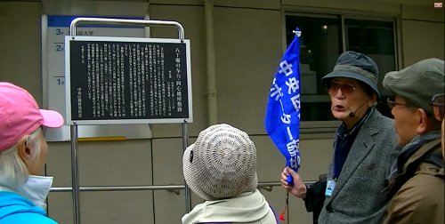
The second part of the second part is a course that follows the eastern edge of Edo Maejima at the site of Kaedegawa from the ruins of the Tsukiji River to Hatchobori and Kabuto-cho. About 50 participants gathered in front of Chuo-ku government office and departed in groups. The so-called Mitsuhashi, which spanned Sanjumabori, Kyobashi River, and Kaede River, was also depicted in the Edo Famous Zoukai. At present, there is a trace of the Metropolitan Expressway Route 1. The explanation board in front of Keika Square "Hatchobori Yoriki Doshin-gumi Yashiki Ruins" indicates that this area was the site of the Kumiyashiki (photo). During the Edo period, Tenso Shrine appeared at the site of Isobe grand shrine in Betsugu in Ise outer shrine.
Crossing Yaesu-dori, the area around "Edo Momiji-dori" was former Motozaimokucho, which was Kiba in the early Edo period. The area around Shinbabashi is the remnants of the two major fish markets in Edo along with Nihonbashi, where the Shinkashibaba is located. Hie-jinja Shrine auxiliary shrine Kayabacho Yakushi is known for its gardening shop in resting place of portable shrines,guardian angel in Edo. Kabuto Shrine was located at the site of the Makino family in the Edo period, and in the Meiji period, Eiichi Shibusawa's residence was located. This area was on the eastern edge of Edo Maejima, where Kaedegawa was in contact with the Nihonbashi River and was the most congestion of boating. At present, traffic congestion on the Metropolitan Expressway viaduct has changed. This historical walk has ended in Nihonbashi. @ Akira Makibuchi
[Akira Makibuchi / Sharakusai]
April 15, 2014 09:00
The first part of the Spring Chuo-ku History Walk 2014 "Walking Edo Maejima" was held on April 12 (Saturday). This historical walk was designed to follow the early Edo-era terrain called "Edo Maejima", which is the prototype of Chuo-ku, and to visit historic sites around the surrounding area. Everyone who applied in the ward bulletin "News of the Ward" participated. Click here.>>
On the first day, about 50 participants gathered and departed at Sukiyabashi Park (Yasuaki Elementary School side), where sprout began to fall under good weather. This area was once the outer moat was located, and to the west it is close to Hibiya Inlet. The road that walks south along the JR elevated line is thought to be the western edge of Edo Maejima. The area near the site of Tsuchihashi near Shimbashi was the intersection of Horiwari. To the west, the outer moat flowed toward the tiger gate and Tameike, and to the east the Shiodome River. If you go east across Chuo-dori, you will find the ruins of Sanjumabori. The area near the ruins of Horai Bridge is probably around the southern edge of Maejima.
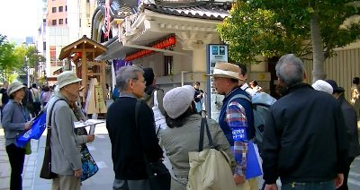
When you go north on Showa-dori, you will see the "Morita-za Ruins" explanation board in the former Kibiki-cho. It is the ruins of a play town in the early Edo period. While watching Kabukiza (pictured), it is said that the area that crossed the Tsukiji River ruins (currently Tokyo Metropolitan Expressway) east through the Meiji Kaido ruins is near the eastern edge of Maejima. The two-hour historical walk in front of the Chuo-ku government office at the dissolution site has ended.
In this historical walk, you can still experience the urban formation and town development of Edo that makes use of the terrain of the sandbar called "Edo Maejima". Walking in comparison with the Geographical Survey Institute's "Land Condition Map" will deepen your understanding. @ Akira Makibuchi
◇The second part of the second part will be held on Sunday, April 20 on a course from the ward office to Edobashi along Kaedegawa River (application deadline has been completed).

