Chuo-ku Tourism Association Official Blog

Chuo-ku Tourism Association correspondent blog

Introducing Chuo-ku's seasonal information by sightseeing volunteer members who passed the Chuo-ku Tourism Association's Chuo-ku Tourism Certification and registered as correspondents.

List of Authors

>>About this blog

Recent blog post

◆ Kyobashi Monogatari 1 ~ The corner seen from Ginza

[Sumida Fireworks] January 31, 2019 12:00

Today, I came to the rooftop of Ginza Six.


After walking through the crowds of Ginza Street, when you come here, you will feel a little calm. It's also a good idea to take a leisurely tour of the rooftop and look for Tokyo Tower and Sky Tree. But there are other things I would like to see. It's the streets of Ginza. Among them, the best one is the 4-chome intersection.

s_hanabi_68-1.jpg

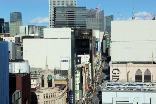
Wako's clock tower is really good. However, I have the impression that the city of Ginza is more crunchy than I expected. 


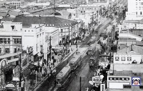
Before Ginza Six was built, the Matsuzakaya Ginza store was located in this place. The pre-war landscape from Matsuzakaya was like this (around 1933).

s_hanabi_68-2rv.jpg

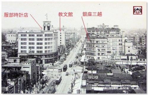
Ginza is more refreshing than it is now, about 10 years after the Great Kanto Earthquake. Wako, which stands at the 4-chome intersection, was called Hattori Clock Store at this time. To the right is Ginza Mitsukoshi, and beyond the Hattori Clock Store, Kyobunkan is visible.


Looking at the history, these three were built in the following years.

    Ginza Mitsukoshi, 1930 (1930) 

    1932 Hattori Clock Store

    1933, Kyobunkan

If we can go back little by little to the past, the building will disappear in a new order. This time, I would like to change my taste a little, go back in time in the past, and guide you to the time trip on Ginza Street.


First of all, I went back a little, but there is a building that has disappeared. Do you understand?

s_hanabi_68-3.jpg

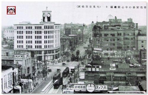
According to history, the Kyobunkan has disappeared. Since the Hattori Clock Store is built, it is the scenery around 1932, the year before the Kyobunkan was built.


The architect of the Kyobunkan is Antonin Raymond. In the city of Ginza, there were several buildings he designed, but Matsuzakaya, who is now there, also had an age of his design.

On the other hand, Hattori Clock Store. This clock tower was the second generation, and the first clock tower was built in Meiji 27 (1894). After the first generation was demolished for renovation, the Great Kanto Earthquake struck, and nine years after the earthquake, the second generation was built.


Let's take a look back. It is a 4-chome intersection around Showa 4 (1929).

s_hanabi_68-4rv.jpg

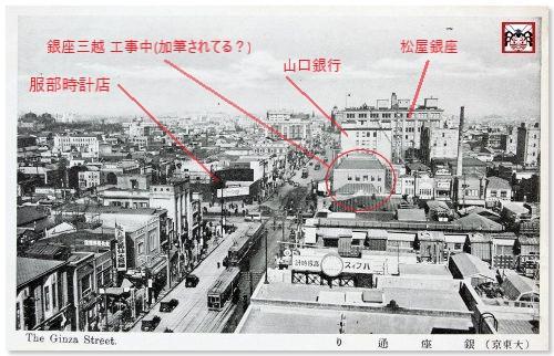
The building of the Hattori Clock Store is gone. There is a crane across the street, so Mitsukoshi is under construction. Beyond it is Yamaguchi Bank, and the big building you can see beyond is Matsuya Ginza, a department store. You can see that Matsuya was already open at this time.


Let's go back further.

s_hanabi_68-5rv.jpg

Then a low-rise ballaque-style building appeared at the Hattori Clock Store. It is the scenery of the first year of Showa. This low-rise building was built after the earthquake, and it is said that Mitsukoshi was occupying and operating temporarily. After that, Mitsukoshi started building a building on the opposite side, and immediately after the Imperial Capital Reconstruction Festival in 1930, opened Ginza Mitsukoshi as a large-scale department store.


Let's go back to the year of the earthquake. Then the building in Matsuya turns into a steel frame.

s_hanabi_68-6.jpg

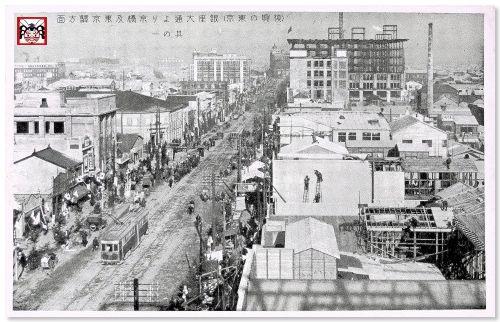
At the bottom of the photo, it seems that the shadow of the steel frame of the Matsuzakaya building appears to be reflected, so it seems that the buildings of Matsuya and Matsuzakaya were both steel frames. Historically, the opening of each business has been completed.

    December 1, 1924, Matsuzakaya

    May 1, 1925 Matsuya, 1925

That's why it's a landscape around 1924. Speaking of 1924, the year after the Great Kanto Earthquake, you can see the reconstruction of buildings here and there in this landscape.


As you can see, the roof of today's Ginza Six was a place where we have been watching the reconstruction of the city of Ginza since the Great Kanto Earthquake.


Matsuzakaya is a large-scale department store that opened for the first time in Ginza. At that time, Ginza 6-chome was called Owaricho, and the building was built by Kunimitsu Life Insurance. Kunimitsu Life opened on the upper floor, and Matsuzakaya entered on the lower floor and set up a store.

s_hanabi_68-7.jpg
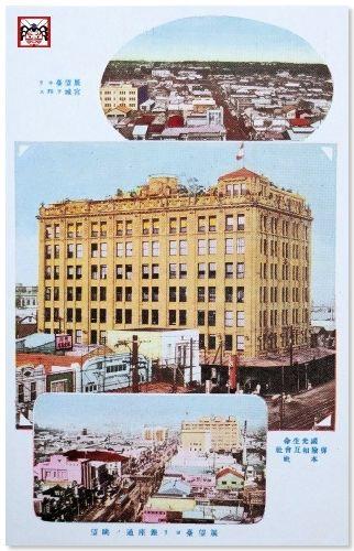
I can't believe it now, but it's a hot topic as the first department store where you can enter the entire building foot. There is also a bustling rooftop zoo and a yellow shuttle bus from nearby stations, and with the opening of Matsuzakaya, Ginza will change from a luxury-oriented city to a city that can be enjoyed by the general public.


On the other hand, how was Matsuya Ginza? I can't see it a little far away, so I'll move in the air and approach it.

s_hanabi_68-8.jpg

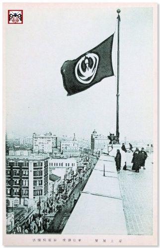
The flapping flag is the Matsuya mark designed from pine and crane, and the below is Ginza Street. This is the rooftop of Matsuya after completion. I look at the direction from Ginza 3-chome to 1-chome.


Matsuya opened in 1925, about six months after the opening of Matsuzakaya. Matsuya itself was founded in Yokohama in 1869 as Tsuruya, so this year marks the 150th anniversary of its founding. The 8-story building will be constructed by a life insurance company. However, on the way, Matsuya decided to move into the lower floor, and the design change made a large atrium. Even if you are hit by the earthquake in a steel frame, it will open 20 months later.

s_hanabi_68-9rv.jpg

In particular, the interior seemed to be very luxurious, attracting many visitors to the store and exposing the topic. After this, together with Matsuzakaya, I will become a leading player in the reconstruction of Ginza.


If you move your eyes to Ginza Street, you will see a large building diagonally opposite. This is the main building of the Okura Gumi, which was completed as a five-story building in 1915. At the time of construction, it was the tallest building in Tokyo.

s_hanabi_68-10rv.jpg

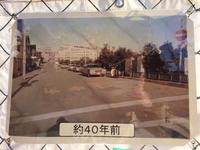
As you can see from the year it was built, this building survived the Great Kanto Earthquake. Speaking of the main building of the Okura Gumi, it is also known when the first building with arc lights was lit, but it was about 40 years ago of this landscape. The photo shows the scenery of the second generation building, the first year of Showa. The current OkuraHouse, where Cartier enters, is the fourth generation.


What I'm worried about is the buildings that can be seen at the "end of the corner" across Ginza Street. The cityscape with a good atmosphere that makes you feel a Taisho romance is spreading. It must be a wonderful city.


Let's move in the air to the rooftop of the Okura Gumi Main Building and approach a little closer.

s_hanabi_68-11.jpg
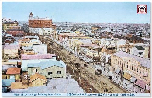
The tall building with the "tongari roof" on the left and the "circular dome" on the right are impressive. It was the first year of Showa.


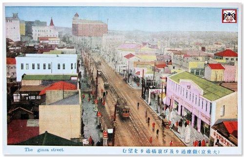
I'm going to enter the Taisho era in this place. It is the street at the end of the corner around Taisho 14 (1925).

s_hanabi_68-12.jpgWhat? Something has changed.

The tongari roof has been turned into a circular dome. It seems that it was not a tongari roof in the Taisho era. The town at the end of this corner was the current Kyobashi, and at that time it was the name of Minami Temmacho. The Kyobashi River flows at the corner, and "Kyobashi" should be built on it. At this time, only a few years after the earthquake, what kind of development did the city lined with large buildings?


I'll do it this time. Time slip and aerial walk on Ginza Street. How was it? From next time, I would like to introduce the cityscape of this "turning corner" in chronological order. It was a prologue of "Kyobashi Monogatari".

(References are scheduled to be compiled in the epilogue.) 


"Edokko" Reconsideration   

[CAM] January 30, 2019 14:00

After reading "Nyanboku"'s post, "What is Edokko?"

>There is also a detailed description of CAM's "What is Edokko?"

 /archive/2017/09/post-4591.html


 Thank you very much for referring to my previous post.


 I have concluded the previous post as follows.


>As a Kansai person, I felt a physiological disgust of the word "Edo kid" or race, and by Seiryo Kaiho (1755-1817), "Edo things are children's nasty, stupid, It's a culture that has sympathized and agrees with the theory of "Edo, the first time that should not be understood."


 Nowadays, overconcentration in Tokyo is progressing, and Osaka is declining to be said to be the "top of the region." However, one of the reasons why the capital was changed to Edo (Tokyo) in the Meiji era is that "Osaka will be able to maintain prosperity even if it is not the capital, but if Edo is no longer the capital, it will be lonely." When I think that there was something, I can't stand the feeling of the past and present.


 It was "Yoroku" in the Mainichi Shimbun the other day, or as a description of the introduction department that tells "the arrival of the Osaka era" of tennis, "If the location of the government is the name of the era, as in Nara period, the Kamakura era, and the Edo era, the era when Hideyoshi Toyotomi took government affairs at Osaka Castle should be the Osaka era. " The expression "Azuchi-Momoyama period" in the history category is obviously unfair. At least I think it should be called the "Azuchi Osaka Era". This is also thought to have been a conspiracy of the Historical Society of Tokyo.


 Even when the prefectural system was created, it is said that Takarada was afraid of the Tokyo government that Osaka Prefecture was too strong to divide the Settsu region and transfer part to Hyogo Prefecture. . If you read Ryotaro Shiba's "Ryoma Goes", you can see that Kobe and other places in late Tokugawa shogunate were not yet urbanized.


 I walked in the area of the current Chuo-ku, which should be called `` Hara Edo '', and found in Nihonbashi, Shinkawa, etc., the remnants of the days when Osaka and Kansai were powerful, so I wanted to study the history of Chuo-ku It was the starting point.


Let's follow the streets with the era in Chuo-ku (Part 1)

[often slap] January 30, 2019 09:00

On May 1, this year, the Crown Prince was enthroned as the new Emperor and switched to a new era.
In the streets, "The Last of Heisei"...It was around this time when I often see and hear the word ""
 

Did you know that there are several streets in Chuo-ku with the name of the era?
 

Today, of such "the street with the era", those passing through Chuo-ku are passed.
I would like to introduce it in two parts, dating back to
Heisei.
 

■Part 1 "Heisei-dori"
sbt_1901_01.JPG
Nihonbashi Kabutocho No.2 (Amibashi Minamizume) 2-15 Tsukiji (intersection with Harumi-dori St.)
It's a street running parallel to the west side of Shin-ohashi-dori St.
I don't know why it became the name "Heisei-dori"...。
(I would like somebody to explain to you!)
 

sbt_1901_02.JPG sbt_1901_03.JPG
In Kabuto-cho and Kayabacho near the starting point, the Tokyo Stock Exchange (Photo 1) and the Tokyo Stock Exchange (Photo 1).
In addition to the auxiliary shrine Hie-jinja Shrine, it reminds me of the period of high economic growth.
Office buildings (second photo) are lined up.
If anything, there is a taste of "Showa", but it is also a taste of "Showa".
Redevelopment of the area has begun beyond the era of Heisei.
I feel the flow of the times.
 

sbt_1901_04.JPG
Tsukiji near the end point is also the Historic buildings selected by Tokyo.
There is a building of "Miyakawa Shokutori Chicken Egg" (built in 1929).
In addition, there are historic sites along the road, such as the site of Shintomiza and the site of Hoshu Katsuragawa Yashiki.
While saying "Heisei", it has become a way to have various eras.


■No. 2 Showa-dori
Connecting Shimbashi (Shimbashi 1, Minato-ku) to Ozeki Yokocho (5, Negishi, Taito-ku).
It is a wide street between Shimbashi and Ueno, including in Chuo-ku.
It runs parallel to the east side of Chuo-dori.
 

The Heisei-dori just mentioned is parallel across the Metropolitan Expressway.
 

sbt_1901_11.JPG sbt_1901_05.JPG
This road was constructed after the Great Kanto Earthquake that occurred in 1923 (Daisho 12).
This symbol road was created as a centerpiece of reconstruction city planning.
In 1931 (Showa 6), when the era was just changed to Showa.
Since it was completed, it was nicknamed "Showa-dori".
It was a street that symbolized the new era of Showa.

Its wide width (44 meters) has plenty of street tree belts and sidewalks.
It is also a remnant planned as a park street.
(By the way, at the beginning of the concept, it was planned with a width of 108 meters.
It's more than twice the current width!)
Looking for an old photo in the library, when it was completed, it was between the upper and lower lanes.
It seems that there were two rows of trees and sidewalks. (Partial as parking lots)
It seems to have been used.

 
sbt_1901_07.JPG sbt_1901_06.JPG
The current figure is a section with three or more lanes one way, an underpass dedicated to passing traffic underneath.
In the north of Edobashi, the underground parking lot connected from there is an overpass of the Metropolitan Expressway overhead....
The structure emphasizes functional aspects, handling a large amount of automobile traffic as an aorta in the city center.
In a sense, it has become a road that symbolizes the Showa era, especially the post-war era.
 

Nowadays, it is often thought that there are no sights or highlights just because there are many streets.
This Showa-dori is located along the Nihonbashi Post Office (the birthplace of mail), a monument derived from Betta City, and a monument derived from the city.
Historic sites such as the ruins of Kano Art Juku and like the Nihonbashi Diamond Building (formerly Edobashi Warehouse Building).
In addition to the famous buildings
In Nihonbashi Honmachi, there are Ozu Historical Museum and Daiichi Sankyo Medicine Museum.
There is also a spot.
 

If you walk separately from Heisei-dori and Showa-dori from the viewpoint of street, you can see that you can walk around.
There seems to be a different kind of fun again!


By the way, next time I would like to go back to the Taisho era.
Some people think, "There is no Taisho-dori!?"
Actually, when you go back to the past, there was also Taisho-dori in Chuo-ku.
I'm looking forward to it!


What is Edokko?

[Nyan,] January 29, 2019 09:00

"Hey, what kind of temperament do you say when you say Edo kid?"
"That's that, you don't have any money for the evening, or you're a genuine Edo-no-enuki?"
"Yes, Mr. Kyoden Santo has defined some other things, such as Iki and Hari as the main territory. Well, I say, "I'm born in Shiba and grow up in Kanda."
"Oh, I'll tell you. Kanda is a townman that symbolizes Edo, so Kandakko says like a synonym for Edokko."
"Now, Nihonbashi is mentioned as the center of Edo, but why do Kanda speaks to represent Edo?"
"Oh ... Well, Edo was originally a Minato built in "Enodo" where the Sumida River and others flowed in, so I originally mentioned the area around Edobashi and Nihonbashi."
"Oh, I know well. That's right. In the "Edo direction map", it was written as "Kanda to the north and Edo to the south", and it was strictly considered that Edo and Kanda were different. Then why is Kanda kid synonymous with Edo kid?"
******
"...?"
******
"... I'm living with youYllaYllaYllaYllaYlla" (abbreviated below)

"The answer is," because I didn't get hired! !"」
"Eh? ? ?』
 
・・・ You who say that the expressway has ruined the scenery of Nihonbashi ...
 
************ (as one of them because I think there are various theories) ************************
Nihonbashi is located in front of Tokiwa Bridge Gate in front of Edo Castle, and was a region where supplies from the top and from all over the country gathered and scattered.
In addition, it has a function as a financial center including Koza, and is an area created as the center of the castle town, as the name Honmachi.
Here, upper merchants with headquarters in Ise, Oomi, Kyoto, etc. set up large stores. This Edo branch, that is, the Edo store (Dana), is a place to earn money thoroughly, and the clerks were brought from the upper head office, so they did not hire them locally in Edo.
There was no voice to those who said, "I don't use the money of the evening." They had no choice but to get a job in Kanda, a little away from Nihonbashi, and to become a full-fledged craftsman or merchant.
(This is described as "I didn't get hired" to a large store.)
 
It seems that the townspeople outside Kanda Hashikado had to create a unique atmosphere = Kanda kid that could coexist with them surrounded by samurai and shopkeepers.
(Reference: Tokyo people "Towners Following Edo" (October 2016 issue))
**************************
karuta.jpg
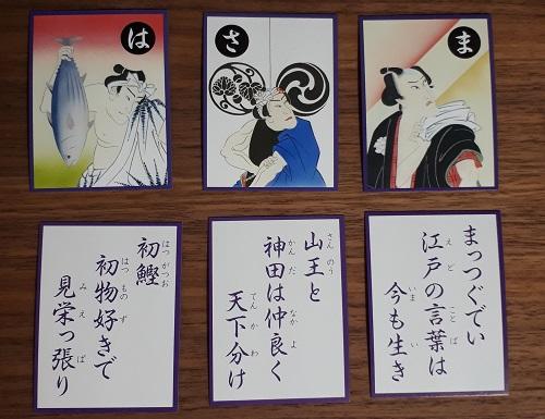
(In the photo, I chose something that seems to be related to Edokko rather than Nihonbashi Karuta.)
kanda.jpg
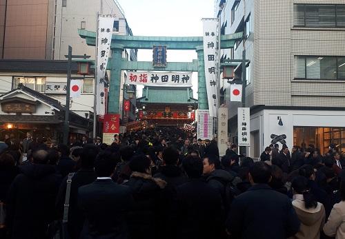
(In addition, Kanda Myojin (because Edokko refers to people born in Sanno Gongen and Kanda Myojin shrine parishioner area)
 
There is also a detailed description of CAM's "What is Edokko?"
 /archive/2017/09/post-4591.html


Relief of Akatsuki Bridge

[Silver Fox 007] January 27, 2019 18:00

Chuo-ku has a long history as a city of water transportation. I think most canals are now reclaimed, and many bridges are part of roads. The name of such a bridge remains on St. Luke's International University from Tsukiji Station on the Tokyo Metro Hibiya Line. It is Akatsuki Bridge over a park that reclaimed the Tsukiji River.

The other day, when I was passing through Akatsuki Bridge, I found such a relief on the wall (direction of Honganji) on the side where the park is being renovated! I've been passing by without notice at all. Did you organize the planting for construction? Or if you don't want to see it, you can't see it.

20190121 Relief of the settlement. jpeg


20190121 Ministry of Naval relief. jpegThe photo above is entitled "Tsukiji Reservoir (now Akashicho)" and is written by Gardiner in 1894. The origin of this painting is thought to be owned by Rikkyo University (see the Tsukiji Foreign Settlement History Map published by the NPO Tsukiji Reservation Study Group). And the photo on the right (installed near Tsukiji Station) is "Tsukiji Navy's training ground balloon demonstration (currently Tsukiji 5-chome)" and the Maspro Electric Works Museum, which provides materials. All are engraved with Chuo-ku Civil Engineering Department Park and Green Space Division, but there is no date of installation.

I'm sorry for the photo, please go out for a walk and take a look.

The map of the settlement is a bird's-eye view of the direction of St. Luke's International University Chapel with this relief behind, and it is a very different building from now. The figure of the Ministry of Naval would be an event at the Ministry of Naval, facing the relief, on the left hand side, in the direction of the Tsukiji Market.


Along the fence under construction

20190121 Akashicho a little ago. Thumbnail image of jpegIf you go to Honganji Temple, you know

Here's a picture of 40 years ago

It was on display.

What is the current situation?


20190121 Akashicho. Thumbnail image of jpeg


Forty years ago, St. Luke's International University (then a hospital) stands out.

Oops! That's right! The street on the Honganji side should also be on the bridge.

I overlooked the name of the bridge. I have to watch it!


Visit Ginza Inari Shrine

[The Rabbit of Tsukuda] January 26, 2019 18:00

The other day, fortunately, I was able to visit Ginza Inari Shrine, which is usually closed to the public. I hope everyone will see the state of the shrine.


Ginza Inari Shrine has been worshiping as a Inari in Ginza since the Edo period, as it can be found in the Chuo-ku Monoshiri Encyclopedia, and thriving business. Currently, due to the progress of land development, it is enshrined on the roof of the Ginza Echigoya Building in Ginza 2-chome. You cannot visit the rooftop at stamp rally around Ginza Hatcho Shrine in AUTUMN GINZA, which is held from late October to early November.


Ginza Inari 1.jpg 
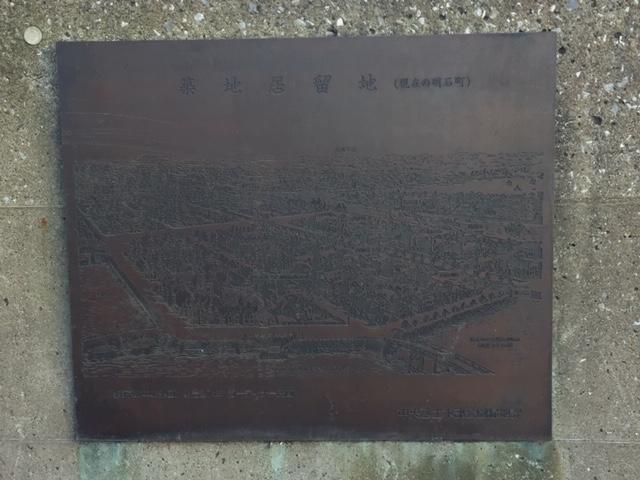
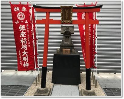
Only Inari was quietly seated on the rooftop.


Ginza Inari 2.jpg 
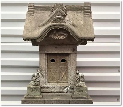
You can see the passage of time in the stone structure.


Ginza Inari 3.jpg
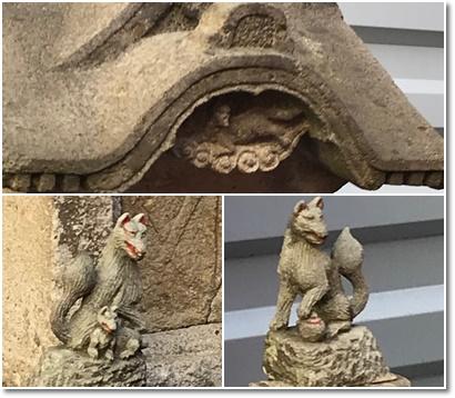
The fox on the left is a fox, and the fox on the right is a jewel.


The street where Inari-san was in the Edo period was called "Kanze Shindo", and there was a Noh Kanze-style mansion. Looking at the map of the late Edo period, it is specially written in inari and red. In everyday life, he would have joined hands on the street. It was a valuable experience to imagine the feelings of the people of Edo on a small lovely fox.