List of Authors
>>About this blog
Recent blog post
|
[Silver]
February 24, 2016 18:00
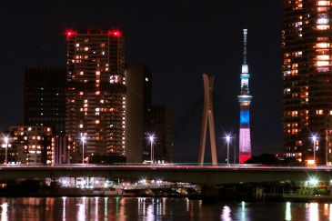
Everyone who is looking forward to supporting and watching the Tokyo Marathon 2016
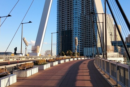
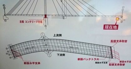
The upstream sidewalk of Tsukuda-ohashi Bridge is undergoing seismic work on the bridge, and the iron bridge from Minato 3-chome side to the bridge has been removed.
On February 24, we were just working on sending concrete with a pump truck.
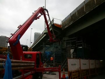
For support and watching on Tsukuda-ohashi Bridge, please use the overpass that rises from the Akashicho side.
Just above, there is a stud at 36km point, but it is the upstream side where it cannot pass.
This point is a little slope, and it is the most difficult passing point for runners.
(Refer to the cat's blog on the slope, which was reported before.) slope, which was reported before.)
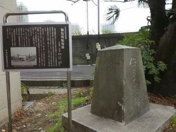
If you arrive on the upstream side by mistake, please see the "Tsukuda Island Ferry Monument" and use the pedestrian bridge on the downstream side.
I hope you  will have a good support will have a good support  and watch the game. Silver and watch the game. Silver
※It is said that this construction will continue until March 31. Please note that those who stroll around Tsukiji, Tsukuda, and Tsukishima.
[Sumida Fireworks]
February 23, 2016 14:00
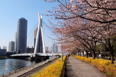
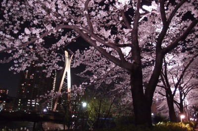
After February every year, you can hear a letter saying, "Kawazu cherry blossoms at the foot of Chuo-ohashi Bridge on the Sumida River have bloomed."
The Sumida River also makes you feel that spring is coming soon.
 (Kawazu Sakura on February 14) (Kawazu Sakura on February 14)
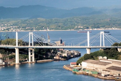
"Chuo-ohashi Bridge" over the Sumida River. This bridge, which opened in 1993, connects the Tsukishima and Tsukuda districts to the Yaesu Exit of Tokyo Station by a single road.
This time, I would like to talk about this "Chuo-ohashi Bridge" that I feel.
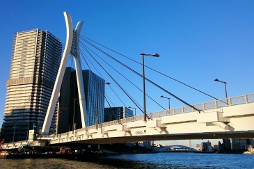
The white and high main tower is very distinctive, but the cable comes out from the top of the main tower, so when you come near this bridge, your gaze naturally turns toward the sky.
The "height" main tower in harmony with this cityscape, which has many high-rise apartments nearby, shows a presence without being buried in the cityscape, and the "diagonal" line created by cables gives a slightly different accent to the cityscape at right angles.
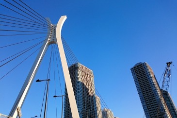
It is this white main tower, but it imitates the shape of a helmet. In the past, the Tsukuda area was an island such as Tsukuda Island and Ishikawajima in the Edo period, but Ishikawajima was once called Yoroijima, and it was called "Kabuto" with a pair of "armor". It is said that it was designed.
It's a helmet.
Depending on your point of view, it looks like a giant who played banzai.
Depending on where you look up, it looks like a "gigantic spider".
 Well, what does each person look like? You may be better at this kind of thing. Well, what does each person look like? You may be better at this kind of thing.
This bridge has a wide sidewalk and can be planted, so you can walk comfortably, but one of the major features is that the bridge girder is large and "curve".
The type of bridge is "Shachokyo". The Shaping Bridge hangs the bridge girder by connecting several cables coming out of the main tower directly to the bridge girder.
It seems that the number has been increasing recently because it can be designed with a high degree of freedom according to the scenery of the place, such as the number of main towers and the position where the cable is to be placed.
 (Example of Shahari Bridge: Onomichi-ohashi Bridge (back) and Shin-Onomichi-ohashi Bridge (front) in Onomichi) (Example of Shahari Bridge: Onomichi-ohashi Bridge (back) and Shin-Onomichi-ohashi Bridge (front) in Onomichi)
In the case of Chuo-ohashi Bridge, the curved bridge girder is hung, so I think that it was probably designed with complicated calculations, but recently such a complicated bridge with such a complicated shape can be realized with a diagonal bridge.
 (plan view of the bridge girder) (plan view of the bridge girder)
Also, the bridge girder is not only a curve but also a bow upward, so if you try to cross this bridge, you will not be able to see the destination you cross.
If you think, "What is the other side of the bridge ahead?", Your feet will head toward the top of the bow and the middle of the bridge girder at the top of the curve.
In the middle of the bridge girder, the best visibility is "outside of the curve" regardless of whether you look at the direction of travel. If you look at the direction of the river here, you will see the "Messenger Statue" by Ossenzackin. The Sumida River and the Seine of France are friendly rivers, donated by Paris, and this statue is displayed in the upper reaches of the Sumida River, toward the Eitai Bridge and the Sky Tree.
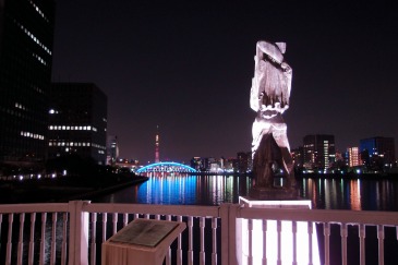 It is a statue holding a sailing ship, the emblem of Paris, on his right arm, but from the top of the bridge, the front side of the statue is not clearly visible, and it is mysterious place of this statue that I do not know what is going on. It is a statue holding a sailing ship, the emblem of Paris, on his right arm, but from the top of the bridge, the front side of the statue is not clearly visible, and it is mysterious place of this statue that I do not know what is going on.
On the north side of Ishikawajima Park next to this bridge is the Paris Square, which shows the friendly relationship between Tokyo and Paris, and the design of the Chuo-ohashi Bridge is also a French design company, so the vicinity of this bridge is "France" and "Paris of Flowers". This bridge may be said to be a symbol of friendship with Paris.
 (November 15, from the Sumida River Terrace on Tsukishima toward Chuo-ohashi Bridge) (November 15, from the Sumida River Terrace on Tsukishima toward Chuo-ohashi Bridge)
And the main feature of the place where this Chuo-ohashi Bridge is located. Isn't that there are three parks where cherry blossoms bloom next to each other?
Tsukuda Park, Ishikawajima Park and Shinkawa Park. In each park, cherry blossoms bloom along the Sumida River in spring, making it a place that adds color to the spring of the Sumida River.
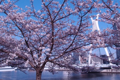 (2015: Ishikawajima Park) (2015: Ishikawajima Park)
When you walk through the park, you will just put cherry blossoms and Chuo-ohashi Bridge in the square in the photo. There may not be so many bridges surrounded by cherry blossoms.
 (2015: Shinkawa Park) (2015: Shinkawa Park)
If you look at it in this way, the spring Chuo-ohashi Bridge looks like a "koto".
The cable is thread, and the white main tower is like a huge koto pillar, "Spring Sea" or "Sakura Sakura" ... You can hear the performance of spring.
 (2015: Tsukuda Park) (2015: Tsukuda Park)
The cherry blossoms bloom in spring. It seems to take a little longer to visit, but when it gets warmer and the season comes, try surrounded by cherry blossoms blooming around Chuo-ohashi Bridge.
And how about trying to feel the sound of spring?
[Dye]
February 9, 2016 09:00
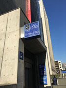
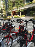
"Chuo-ku community cycle" started on October 1, last year.◎
I needed to register at first, and I thought, "Oh, registration?", But it was easier than I expected.
It's super convenient and I'm using it (^^)♪
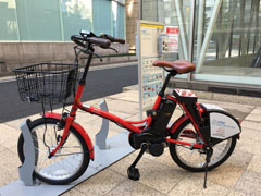
Handle, saddle, basket shape, presence or absence of mirror...It's a little different, so you can choose what you like.
◆Chuo-ku Community Cycle
HP: http://docomo-cycle.jp/chuo/
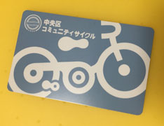 
You can also issue an IC card with 500 yen plus. Just hold it.
Even if you don't have it, you can enter the number issued online.
There are plenty of subways in Tokyo, but it is often faster to go from the ground if you change the line and get on one station. 。
In such a case, he responded exactly to the need for a bicycle rather than walking (` ・ ω ・ ')!
From February 1, wide-area experiments have been conducted in four wards of Chuo-ku, Minato-ku, Chiyoda-ku, and Koto-ku, and it has become even more convenient because it can be returned anywhere.
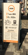
The number of ports where bicycles are placed is 123 in total (as of the end of December 2015) in the four wards.
◆Bicycle sharing wide area experiment
HP: http://docomo-cycle.jp/tokyo-project/#notice
Immediately the other day, I borrowed it at a certain place in Minato-ku, completed it around Ginza 6-chome, and returned it to Takaramachi in Chuo-ku.
I really did it.☆
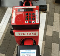 
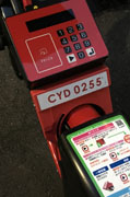 
I think TYO is Chuo-ku, MNT is Minato-ku, and CYD is Chiyoda-ku.
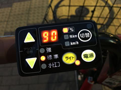
It's electric.☆
If you go on the same journey by walking with the train, isn't there more walking? It was like that, but by bicycle, I was able to shorten the time. You can also see the streets.  
You can also see some other ward and private bicycle parking lots, so when you park your bicycle in between, use these places and avoid unnecessarily parking.☆
◆Parking lots and bicycle parking lots in Chuo-ku
HP: http://www.city.chuo.lg.jp/sisetugaido/tyusyazyo/
  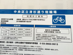
It's also near the Mitsukoshi underground and near the station. The photo shows near Kyobashi on Showa-dori and near Higashi-Nihonbashi Station.
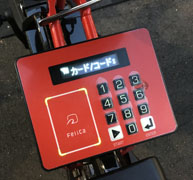
Locking alone will not be returned, so when returning it, "locking" at the port. → "Enter".
It seems that it detects the weak current coming out of the metal fittings that fix the tire and recognizes it as return.
From February 6 to February 10, the Safe Driving Campaign☆
It seems that there is a free distribution of helmets (limited quantity) at the Nihonbashi Information Center on the 1st basement floor of Coredo Muromachi for registered users. ← Distribution has ended due to favorable reception.
Ginza, Nihonbashi, Tsukiji, Tsukishima, etc....
Enjoy the cityscape and sightseeing of Tokyo by bicycle♪
[Sam]
February 8, 2016 14:00
 An annual mini-garden guided tour that takes a walk around the park with the guidance of a green adviser at the Pocket Plaza "Flowers, Water and Trees" in Harumi Triton Square. An annual mini-garden guided tour that takes a walk around the park with the guidance of a green adviser at the Pocket Plaza "Flowers, Water and Trees" in Harumi Triton Square.
This month was held on February 4th. (12:30~ 14:30~)
The theme this time is "Plants in the Garden of Ritsuharu".
The squirrel (Gomasaceae), which I mentioned last time, is planted by people, such as the flower terrace, slope garden, South Triton Park, but the sunny, South Triton Park, is the plumpest and energy. It is blooming.
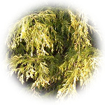
The filiferralia (Hypressaceae), which is characterized by a thread-like hanging golden leaves, seems to have a more vivid yellow taste in South Park. (upper left)
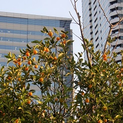
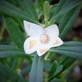
A white flower with a new face of the orange family blackware on the flower terrace.
It is a cute star-shaped flower.
When you rub the leaves, it smells unique to citrus fruits.
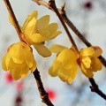
In the slope garden along the Asashio Canal, Kinkan shines orange in the sunset.
On the green terrace, red plums and heart wax plums are eye-catching.
You can rest your mind with the calm and calm fragrance of Soshinrobai.
If you pay attention to your feet, just before pheasant's eye, a typical flower that tells spring, sprouts.
I'm looking forward to the future.
On the terrace area, winter buds that eventually become leaves and flowers look into the branches of trees that had dropped the leaves in winter.
Near the winter buds, there are traces of leaves falling (leaf scars), and the shape and arrangement of each are seen in the eyes, ears and mouth, and the whole situation looks like a human or animal face, and humorous Invite smiles.
They also gave a lecture on how to grow differently according to the type and variety of succulent plant and procedures at cutting.
In addition, it was a plant walk with a wide range of ways to enjoy watching flowers and trees in the winter.
From the left, Kuroware, Kobai, Soshinrobai, pheasant's eye
From the left, horse chestnut, maple, Kashiwaba hydrangea, hydrangea
[Silver]
February 6, 2016 09:00
You can take a walk on Tsukishima and experience the history of Tsukishima from the end of the Edo period to the Meiji era.
Tsukishima was reclaimed in 1887.
I would like to introduce two information boards that will tell you about such things.
The first is an explanation version of the "Tsukudajima Battery Ruins" installed around 1-14 Tsukishima. In that explanation,
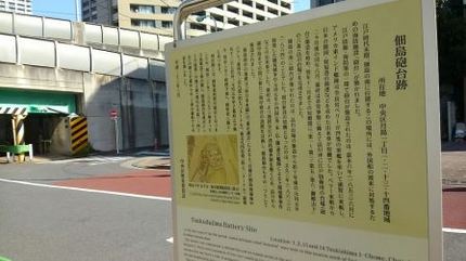
At the end of the Edo period, this place, located south of Tsukuda Island, was built with a sea defense facility called "turret" to cope with the arrival of foreign ships.
The battery was built as part of the Edo defense and maritime defense measures, in June 1853, U.S. East India Fleet Commander Perry arrived in Uraga with four warships, opening Japan and opening a trading port. It was triggered by an event that asked for the opening of a port.
Two months after Perry's arrival, in August of the same year, the Shogunate began building a daiba (turret) for defense of Edo off Shinagawa in preparation for an emergency, and in the short period until November of the following year, "First to Third, Fifth, Sixth, Goten Yamashita "(Shinagawa Daiba) have been completed.
The battery was built south of Tsukuda Island in 1864 (1864), about 10 years after the construction of Shinagawa Daiba.
The triggers for the construction of the battery were events such as the Satsuhide that broke out in 1863 (1863) and the Shimonoseki bombardment by the Shikoku (UK, United States, France, and Orchid) Union Fleet in 1864. .
The Shogunate planned to install a new coastal battery between Shinagawa and Ecchu Island in order to establish a stronger Edo Bay defense posture, and the Tsukuda Island Battery was also built as one of them.
According to "Tokyo Tsushi" in the "Tokyo City History Report", the size of the Tsukuda Island Battery is "Minami Marine Niari on the southern tip of Tsukuda Island, Kyobashi-ku". Approximately 70 meters from east to west, approximately 70 meters from north to south, approximately 72 meters from east to west, approximately 1,377 tsubo. The first year of the first year of the first year of the era, the construction of the Koshi shogunate, the repair of the Meiji era, the Ministry of Army Ni genus ".
In the Meiji era, it became a battery under the jurisdiction of the Ministry of Army, but during the construction of Tsukishima, which began in 1887 (1887), the Tsukishima No. 1 landfill (currently Tsukishima 1-4 chome) was based on the Tsukudajima Battery. Landfill was advanced, and it disappeared during the construction process.
March 2011 (date of installation of information boards)
Also, if you walk from Nishinakadori Shopping Street toward Kachidoki, you will find Nishinakabashi.
The article about the replacement of this bridge is also interesting, so I would like to introduce it.
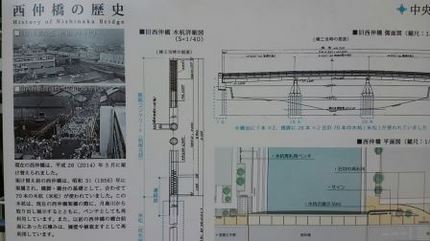
The current Nishinakabashi was replaced in March 2014 (2014).
Before the rebuilding, Nishinakabashi was bridged in 1956 (1956), and a total of 70 wooden stakes (Yonematsu) were used as the basis for piers and abutments.
This wooden stake is taken out of the Tsukishima River at the current Nishinakabashi Bridge and exhibited, and is also reused as a bench. In addition, the masonry in front of the abutment of Nishinakabashi used to be reused as retaining walls and planting.
That's an explanation.
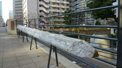
The foundations and bridges of buildings from Meiji period to Showa were used a lot of American and Canadian pine trees.
While thinking about such things, I sat on a reusable bench and enjoyed a walk   on Tsukishima. on Tsukishima.
1
|
Links
|

