List of Authors
>>About this blog
Recent blog post
|
[Slow of Satsuki's Koi]
June 28, 2018 18:00
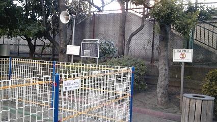
There is a monument of "Tsukishima Passover Site" between Kachidokibashi and Tsukuda-ohashi Bridge. This monument is a bit difficult to understand because it is located in "I Children's Park" inside the embankment slightly away from the Sumida River Terrace. The fact that Kachidokibashi was bridged in 1940 and the number of ferry users decreased, and that Tsukishima ferry was abolished, I think that it was definitely a question for this year's tourism certification test.
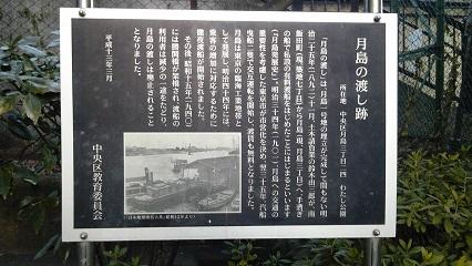
It is said that this Tsukishima ferry was originally a private ferry between Tsukishima and Minami-Iida-cho (currently Tsukiji 7-chome), but if you find it because I think there was something related to Minami-Iida-cho I will post it on.

This area can be seen as a combination of Tsukuda-ohashi Bridge and the wire cable of Chuo-ohashi Bridge ahead and the Tokyo Sky Tree.
Tsukuda-ohashi Bridge was bridged during the 1964 Tokyo Olympics. Before that, there was "Tsukuda's ferry" and I remember boarding the last flight.
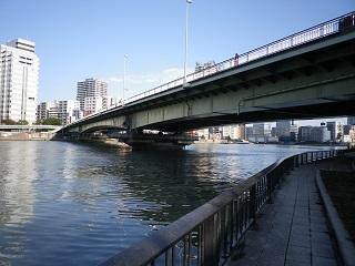 <<< In the foreground, there was "Tsukuda's handover" around Tsukuda side around here. >>>> <<< In the foreground, there was "Tsukuda's handover" around Tsukuda side around here. >>>>
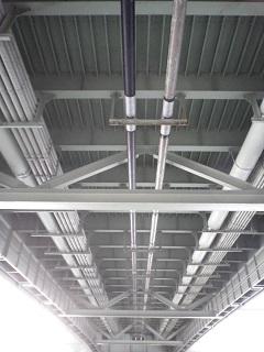 <<<<<<<under a clear bridge >>>>> <<<<<<<under a clear bridge >>>>>
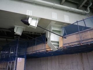
<<<<<<<< earthquake-resistant construction has been performed again and is currently completed.) >>>>>>
If you look under the bridge, it is also earthquake-resistant.
Be careful when crossing by car because Tsukuda-ohashi Bridge may crack down on speeding.
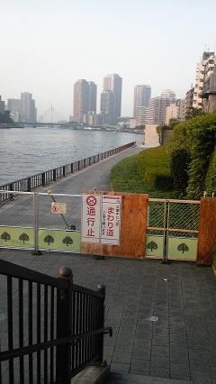
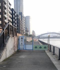
The Tsukishima River Suimon construction, which was posted last time, has not been completed as of the end of June. There is no construction guide for pedestrian bridges and traffic is closed. I was looking forward to it because it would be very comfortable to do this, but what was the progress of the construction? ?
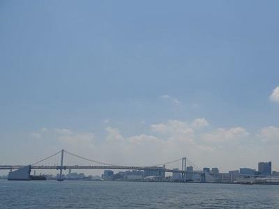
The next time is Chuo-ohashi Bridge.
[kimitaku]
June 28, 2018 09:00
Far from the Urban Gate Bridge to the Harumi High-rise Condominiums
Harumi Ohashi Rainbow Bridge can be seen as overlapping.
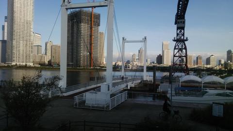

As you walk, you can see and hide these bridges and skyscrapers.
You can enjoy walking. High-rise apartment in Tsukuda, St. Luke's International Hospital
: : : The surface of the Harumi Canal is approaching my feet
My heart is peaceful. ; : : :


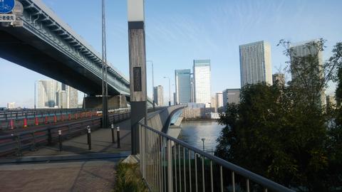
Finally, cross Harumi Ohashi (it's a pretty uphill) and go straight to Kachidoki Station.
Take care.
1 hour and 20 minutes by walking slowly 50 minutes by walking
[Hanes]
June 27, 2018 18:00
Hello. This is a new correspondent, Hanes. 
Where do you look when you walk around the town?
Do you often see things with high eyes and high-rise commercial and complex facilities ? ?
This time, we call it the "How to Walk in Chuo-ku" series, and introduce how to enjoy Chuo-ku from a slightly unusual perspective.
The first one is Chuo-ku, seen from the sky.
There are many rooftops of commercial facilities that are open in Chuo-ku.
Isn't there much opportunity to see the whole ward in a wide area?
If you look at Chuo-ku with an aerial photograph of Google Map, you can try it out.
I get the impression that it is an area blessed with watersides such as the Sumida River and Nihonbashi River.
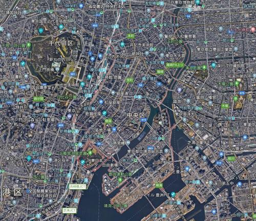
(Source: Google Map)
At the same time, some people may realize that there are many distinctive bridges.
In this way, there are some interesting discoveries when viewed from the sky, so I will introduce them.
■Bank of Japan
As you may already know, many people are in the shape of a circle when viewed from above.
(Source: Google Map)
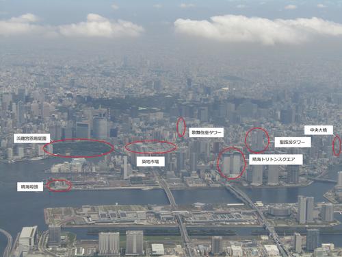
■St. Luke's Tower
I can hardly notice it from the ground, but
When viewed from the sky, it has the shape of a Greek cross (the same length crosses the same length and the axis tree, center).
(Source: Google Map)
(If you drag the image below, you can see the cross part.)
From the Restaurant Luke with Sky Lounge on the 47th floor of this tower, you can see the RestAURANT LUKE with SKY LOUNGE.
You can see not only the Tokyo Tower and the Sky Tree, but also Mount Fuji on a sunny day.
In addition, it is located near the Sumida River.
It is also possible to see the bridge over the Sumida River.
By the way, so far, we have delivered the view from the sky that can be enjoyed from houses and facilities.
However, I would like to recommend it to those who want to enjoy a little more unusual way.
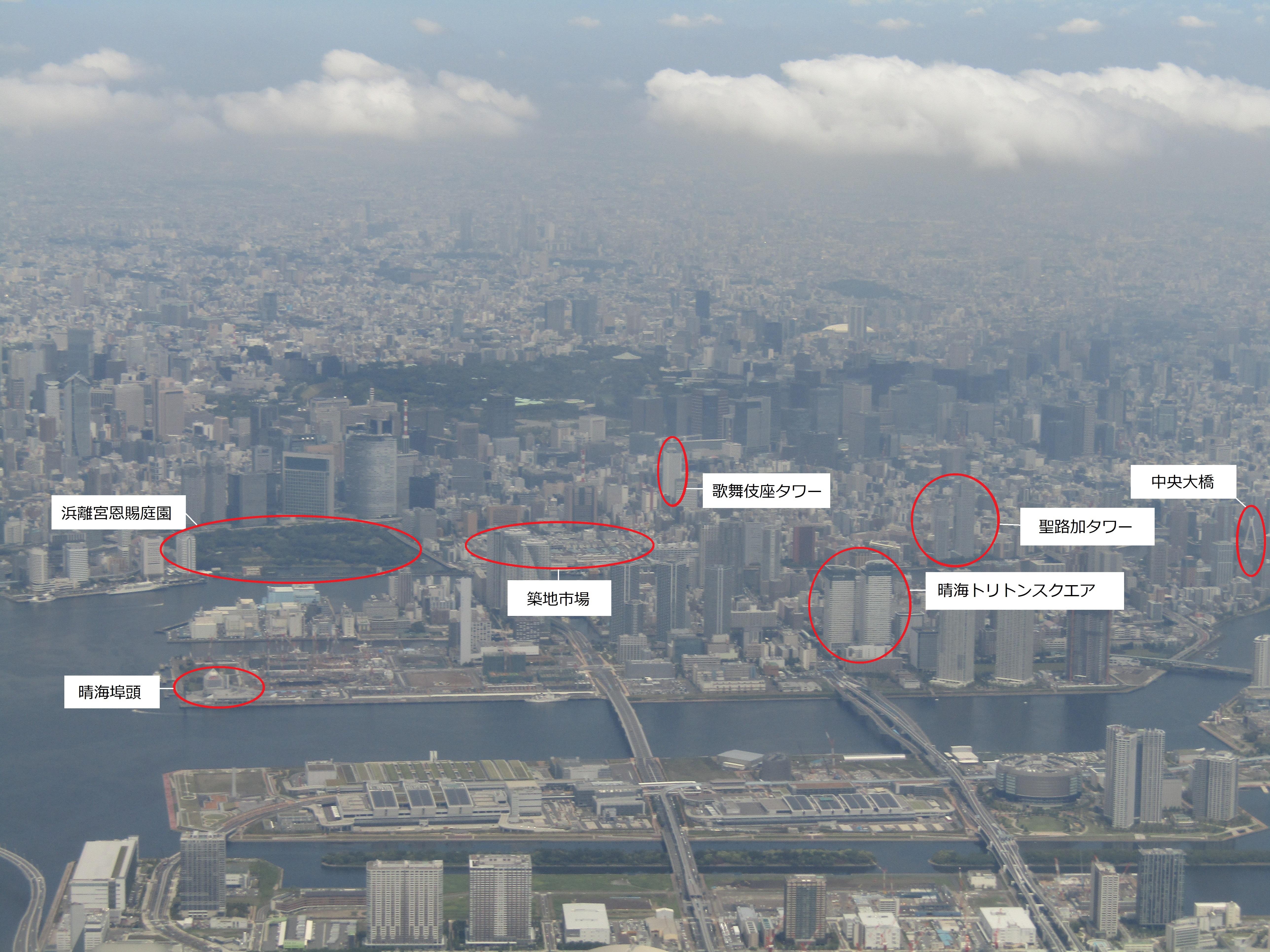
It is a view of Chuo-ku as seen from an airplane.
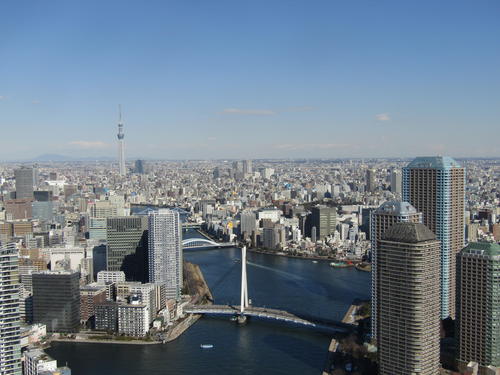
I had the opportunity to use an airplane from Haneda Airport on a business trip and tried to shoot in Chuo-ku.
Unfortunately it was cloudy and not clear, but I was able to take such a picture.
(* Click the image to see it on the enlarged screen.)
The area around Nihonbashi didn't fit well, but you can see a number of distinctive buildings.
It passes before the seat belt sign disappears, so when traveling north from Haneda Airport, take a seat on the window side on the left in the direction of travel and enjoy Chuo-ku from the sky. ?
In addition, on the Geographical Survey Institute's "Geographical Institute Map", you can see prewar aerial photographs of the 23 wards of Tokyo (around 1936) overlaid with the current map and aerial photographs of each age.
The released aerial photograph states that "the oldest aerial photograph owned by the Geographical Survey Institute and whose shooting time is known."
It looks just good to see the prewar Chuo-ku.
When walking around the town, you may visit places you care about with aerial photographs.
[The Rabbit of Tsukuda]
June 27, 2018 09:00
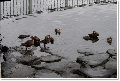
It is a rabbit of Tsukuda who observes fixed points of wild birds on the Sumida River terrace of Ishikawajima Park. This year, 3 pairs of parents and children from Indian spot-billed duck came! This time, there are two of them introduced in the photo.
First of all, on a rainy day on June 10, we found four chicks taken by female parents in the reed grass on the Sumida River Terrace. There is no human shadow on the terrace due to the falling rain. By the way, many birds grow chicks with their parents, but Indian spot-billed duck is only female. It seems that she is eating algae on the pillars while being watched by female parents, about 2 or 3 days after birth.

Ships pass frequently through the Sumida River, so there is a higher risk of being rubbed by the waves and losing the buoyancy of the feathers than chicks growing in ponds and rivers, but I was also riding the waves that approached well. It's safe.
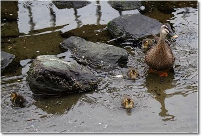
Even though he had a camera, he was still standing still, seemed like a rock, came close to me
It is unique to the Sumida River Terrace that you can see the adorable figure so close. It is the charm of the terrace where the contact point with the river is very close.
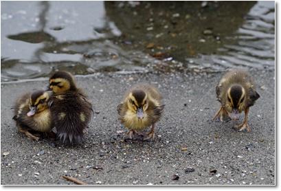
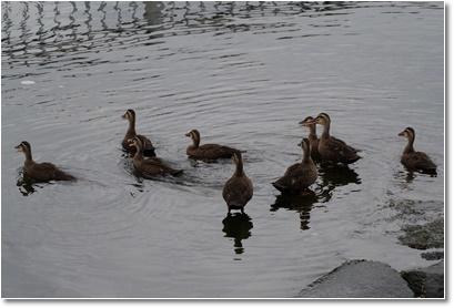
The other pair is on the morning of June 14th. The runners stopped and were photographed with a mobile phone camera. It's such a big family! What's more, can you say that it's a chick? It's big.
There are 9 chicks. My parents are slightly larger in the foreground. Even if you say a chick, is it 2 or 3 weeks after birth because it is this size? The fact that nine birds grew up together so far is a very excellent female parent and mother, given that crows are often targeted.
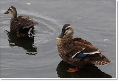
Parents can see that the back wings are partially blue. This is the characteristic of Indian spot-billed duck and is called wing mirror yokukyo. Since there is no chick, it is dark brown overall. Rasako was absorbed in such an observation, but suddenly, suddenly, my parents flew away. It's an impossible event that I've been observing so far to leave chicks!
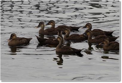
My body is big, but it's still a chick, everyone started singing all at once. Here, "Crying!"

After that, about 30 minutes later, my parents finally joined. In the meantime, another pair of Indian spot-billed duck came and said, "I'm not your parents." Was this an exercise of nesting soon?
In this year's Indian spot-billed duck parent and child, every parent and child had only one day observation, but we were able to report last year and this year for the second consecutive year. "Something happens on the morning walk on the Sumida River Terrace, on a rainy day."
[often slap]
June 23, 2018 18:00
Hello! Today, I would like to explore the planned site of the 2020 Tokyo Olympic and Paralympic Games Olympic Village in Harumi 5-chome.
One of the major concerns of Chuo-ku at the Tokyo Olympics and Paralympics scheduled for 2020 is that the marathon course runs through Chuo-ku and that an athlete village will be established in the Harumi area.
What is the appearance of the athlete village now?

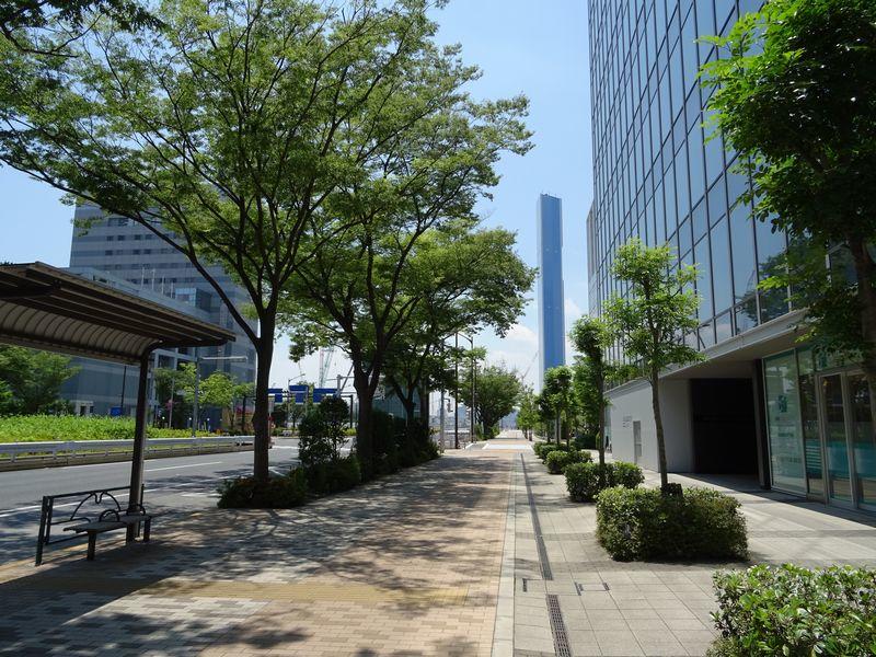
From Harumi 3-chome intersection where Triton Square is located, take the Harumi-dori St. where the tree-lined road is wonderful.
As you go in the direction of the chimney of the Central Incineration Plant ...

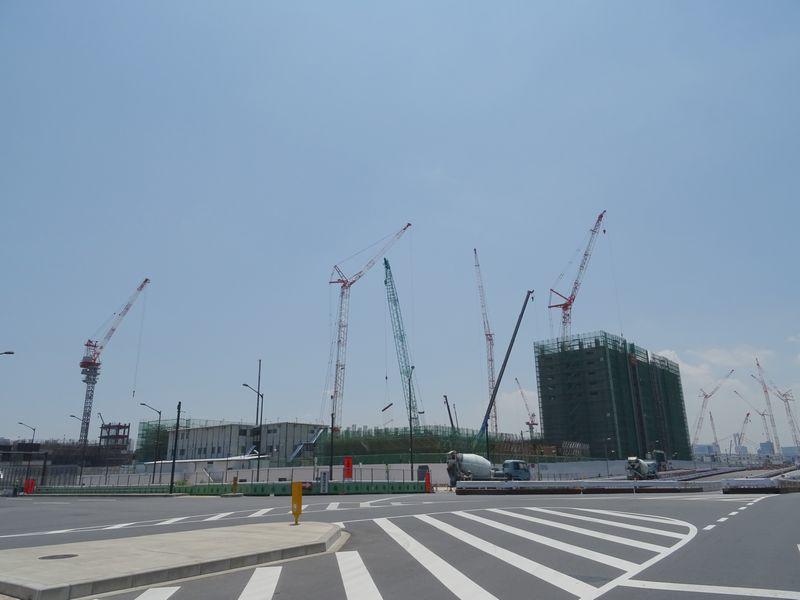
You can see a vast construction site where many cranes are lined up.
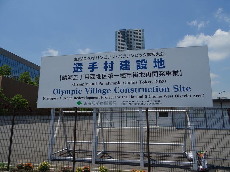
This is the planned site of the Athlete Village.
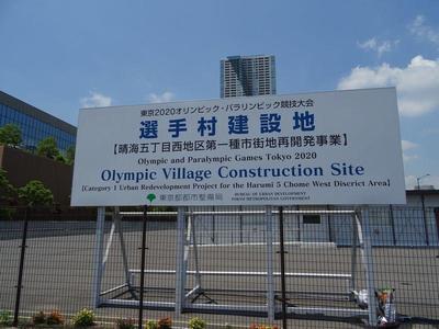
The signboard of "Athlete Village Construction Site" is also displayed. The building to be developed in the urban redevelopment project will be used as an athlete village during the Olympic and Paralympic Games, and will be a general house after the tournament.
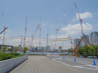
The construction is proceeding at a rapid pace, and the sights that can only be seen now under construction are spreading.
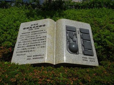
In fact, this is the planned site of the athlete village, where the "Tokyo International Trade Fair venue" was located until 1996.
After the opening in 1959, a number of international exhibitions and events, including the Tokyo Motor Show, were held for nearly 40 years before the completion of the Tokyo Big Sight in Koto Ward. A monument indicating this is located near the Central Incineration Plant.
And going back further, this place was also the venue for the Tokyo Expo, which was scheduled to be held in 1940. 1940 was a year commemorating the 2600 B.C. In addition to the Expo, the Tokyo Olympics were scheduled, but both were canceled due to the effects of the war and became a phantom existence.
It was a land related to such an international event~.
Why don't you not only imagine the future athlete village, but also think about the past history?
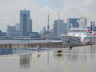 
By the way, from the harbor plaza of Harumi Passenger Terminal, located at the tip of Harumi 5-chome, you can see Tokyo Tower and Rainbow Bridge over the sea, and this is also a recommended spot.
[yaz]
June 22, 2018 09:00
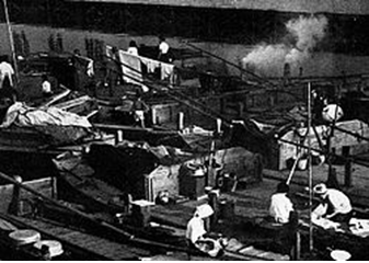
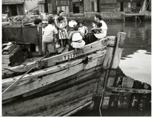
The city of Tokyo is still growing toward the entrance of Tokyo Bay. Offshore Odaiba, the construction of the landfill outside of the central breakwater is still ongoing, but this project was started in 1977 (1977) and is still in the middle of the project. This project, which Ieyasu started reclaiming land and continues, began in Tsukishima in the Meiji era. In the Edo period, soil generated during the construction of bunkers and rivers on land was discarded and reclaimed, but in the Meiji period, mud generated by dredging the seabed to reclaim land.
Tsukishima No. 1 was born by dredging and stacking underwater mud in the Miosakarai project in 1892 (1892). Next, it stretched elongated offshore to No. 2, No. 3 (current Kachidoki, Toyomi), and No. 4 (current Harumi). At the same time, this mio dred project was also the improvement of the mouth of the Sumida River. For many years, the Sumida River removed the mud brought to the seabed and improved the route.
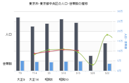
On the river line of Tsukishima and Tsukuda Island, there were many barges such as horse-drawing boats, daruma boats, and motor boats. Goods transported by cargo ships are collected and distributed on a relatively large ship called large barge, and landed on a transshipmented small barge, transport the river line. From the Taisho era to the Showa era, there were 69 rivers flowing through Tokyo City and its surroundings, and water transportation was convenient for transportation. According to a survey by the water department at the end of 1927, the number of barges engaged in water transport was 11,290, and barge was also a workplace for each band. Its population was 31,036 (20,600 men and 10,436 women), and more than half of them were water residents who did not have a house on land. The barge, a place of work and living, was less than 50 tons at large and less than 10 tons at small. The size of the room to wake up was as small as 2-3 quires. There were three to four family members living here. In order to provide the welfare of these residents, a water hall and a water school (a boarding school built on land) were built, and a water police station in charge of security was set up. The exact number of people in Chuo-ku (= Nihonbashi-ku / Kyobashi-ku) at the time of 1927 is unknown, but the graph shows that it was about 240,000, so water residents alone accounted for more than 10%.
As of February 2018, the population of the Tsukishima district (Tsukishima, Kachidoki, Harumi) is 72,780 and the number of households is 37,443. It accounts for 46% of the population of Chuo-ku (= 157,388). It is no exaggeration to say that the population of Chuo-ku always has at the waterfront.

It seems that many water residents did not have a family register, so the actual ratio is expected to have been higher than the above figures.
In the latter half of the 1960s, cargo ships became containerships, and demand for barges in logistics decreased, resulting in a decrease in the number of barges that became integrated with work and housing, and the number of floating residents decreased dramatically due to changes in jobs. On the other hand, in many cases, abandoned barge ships were moored and used as alternatives to houses, but in the 1980s, barge became aging, and it became unbearable and almost disappeared.
|
Links
|