List of Authors
>>About this blog
Recent blog post
|
[Hanes]
December 2, 2018 14:00
Hello! This is a new correspondent, Hanes. 
This time, we will take up the order of the two bridges (each river) in the continuation of [Chuo-ku Tourism Certification Measures] River / Bridge (1).
If you learn the order of the bridge that spans each river at the stage where the name of the bridge has come to mind to some extent
After all, it's recommended to have fun.
How to remember the Hanes style is as follows:
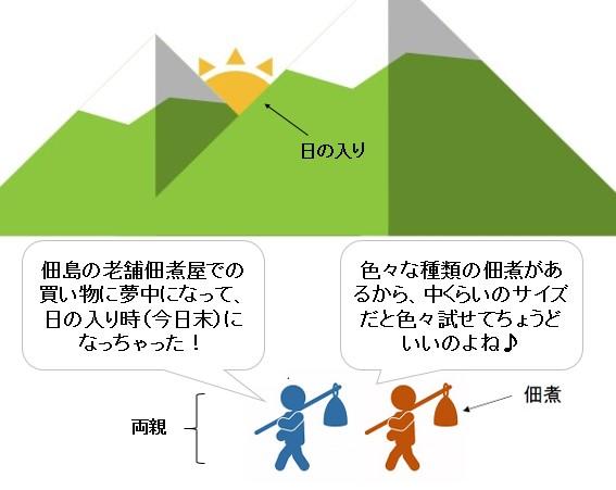
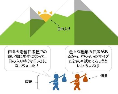
■Sumida River (from upstream/north → south)
"Parents at the end of today, carry Nakatsukuda (boiled)."
Ryogoku Bridge (Ryo), Shinohashi Bridge (Shin), Kiyosu Bridge (Kiyo), Sumida River Ohashi (Su), Eitai Bridge (E), Chuo-ohashi Bridge (Chu), Tsukuda-ohashi Bridge (Tsukuda), Kachidokibashi (Ka), Tsukiji Ohashi (Tsuki)
※The Sumida River Road Bridge, which spans Ryogoku Bridge and Shinohashi, is omitted.
Even if you are a little overdoing it, you will win what you have learned
Isn't it easy to remember if you imagine such a situation?
As expected, my parents don't come back with Tsukudani, but
This may have happened in the past.
■Nihonbashi (from downstream/east to west)
"Wealth, go! At one time in Japan!"
Toyomi Bridge (To), Minato Bridge (Mi), Kayaba Bridge (Kaka), Armor Bridge (Yo), Edobashi (E), Nihonbashi (Nihon), Nishikawabashi (Ni), Ichiishibashi (I / How to read "Ichikokubashi"), Tokiwa Bridge (To), Former Joban Bridge (Ki), New Tokiwa Bridge (Ni / New Tokiwa Bridge (Ni / New)
Is this an image like this?
The wording of the Sumida River was an image of traditional culture, but it was also an image of traditional culture.
Nihonbashi seems to be the current Japan where the inbound spirit is growing.
You can remember the order of the bridge over the two rivers....However, the Chuo-ku Tourism Certification cannot be beaten by this alone.
Where do the Sumida River and Nihonbashi River join, and what is the first bridge to be built after joining?...You need to keep it down to that point!
This will be carried over to the next article.
Last but not least!
■Kamejima River (from upstream / north to south) that I want to keep if I can afford it
The Kamejima River begins at the upstream Nihonbashi sluice gate and ends at the downstream Kamejima River sluice gate.
In the meantime, there are five bridges, and those who aim for a high score should also remember.
The word matching is "Evolution of Reigan! It's expensive!"
Reigishi Bridge, Shin Kameshima Bridge, Kameshima Bridge, Takahashi (Taka), Minami Takahashi (Na) / South = "Nan" / How to read "Minami Takabashi")
There is quite a sense of force, but Reigishi Island is due to landfills and land uplifts.
Please remember along with the history that the sea level was higher than the Edo period.
※In this article, we will introduce some of the reasons for this.
If you remember the contents written here, you won't be able to pass.
Please include it in advance.
Valuable Information| Ningyocho, Hamacho, Higashinihombashi area| Tsukuda, Tsukishima, Kachidoki and Harumi areas| Nihonbashi, Kyobashi and Yaesu areas| History, culture| Tsukiji, Shintomi, Minato area| Kayabacho, Hatchobori, and Shinkawa areas
Page top▲
[Hanes]
09:00 on December 1, 2018
Hello. This is a new correspondent, Hanes.
It's been more than 4 months, but in mid-July, I started appearing on Chuo FM for the first time.
"Instagram is inevitable! In addition to the back story of ROAR COFFEE, which groans both power and concentric.
I talked about the charm of Chuo-ku and how to study the Chuo-ku sightseeing certification for about 15 minutes.
I was just biting it because it was my first appearance.
Thank you to everyone who listened!

The application for the Chuo-ku Tourism Certification started on October 1st.
This time, JUMI, a central FM personality, also introduced me.
I would like to write a little about Hanes-ryu Chuo-ku sightseeing certification measures.
Before that, it was the most important Chuo-ku sightseeing test, but mainly about history and culture since the Edo period.
You will be asked about 100 questions with different difficulty levels.
Among them, the following two things I felt particularly good at.
・River and bridge problems (where rivers and capital heights intersect, where and how many bridges are built, etc.)
・Route problem (which station and which line goes through? If there are multiple routes, the year of opening can be used as a hint for the answer....)
It was less than a year since I started living in Chuo-ku when I applied for the certification.
The scope of action was very limited, and for some time I was commuting on foot.
I didn't have any knowledge of rivers, bridges and routes.
Some of the examinees who are not from Tokyo like me are.
I think there are some people who have similar weaknesses!
This time, we will focus on rivers and bridges, and introduce Hanes-style verification measures to be used as a reference for testing measures.
First of all, I would like to remember the following five things about rivers and bridges.
①Bridge location
②The order of bridges (by river)
③The confluence of the river and the bridge before and after
④It is said to be a feature of the bridge.
⑤Reclamation of rivers
In this article, we will introduce the points of one bridge location (which bridge is (place name) and where (place name) and where (place name)).
■Bridge where the place name is a hint
・Ryogokubashi (2-chome Higashi Nihonbashi, Chuo-ku and 1-chome Ryogoku, Sumida-ku)
This name was given because it connected Musashi and Shimousa across the Sumida River.
・Kiyosu Bridge
At the time of construction, it was named after the connection between Nakasucho, Nihonbashi-ku and Kiyozumi-cho, Fukagawa-ku (currently Nihonbashinakasu and 1-chome, Kiyosumi, Koto-ku), which were on both banks.
■Bridge over the island
I think there are individual differences, but the bridge in the southeast area of Chuo-ku tends to be a pitfall (especially for test takers who are not from Tokyo).
・Bridges span from the Minato, Akashicho, and Tsukiji areas to the Tsukuda, Tsukishima, Kachidoki, and Toyomicho areas
・Bridges spanning the Harumi area from Tsukuda, Tsukishima, Kachidoki, and Toyomicho areas
Like Asashio Ohashi, Asashiobashi, Asashio Kobashi, Reimeibashi, Reimeibashi and Reimei Ohashi
Even if the name is similar, the location and size of connecting are different.
Therefore, we recommend that you keep such information referring to the official text p.196 of the certification released this year!
In particular, the following three items that pass through Ring Route 2, which opened in early November, must be checked.
・Tsukiji Ohashi (Sumida River / between Tsukiji and Kachidoki)
・Reimei Ohashi (Asashio Canal / between Kachidoki and Harumi)
・Toyosu Ohashi (Harumi Canal / between Harumi and Toyosu)
However, Chuo-ku, which has many rivers and bridges!
Don't forget to check the bridge locations in other areas.
I've briefly introduced the points of the bridge so far, but since the study method is for each person, the method that suits you best is the best!
You can put a map on the bathroom and remember it with your eyes, copy the map and remember it by hand.
You can actually walk around the town and learn it with your body.
You can remember your own way of remembering repeatedly with your mouth and ears!
If there are people who can go to the Hanes style, which will be introduced more than once in the future, please refer to it.
※In this article, we will introduce some of the reasons for this.
If you learn the contents written here, you will not be able to pass it.
Please include it in advance.
|
Links
|