Hello, this is Minato kid.
This time, I would like to introduce books published by Chuo-ku. It is available at all libraries, Chuo Ward Kyobashi Library, Nihonbashi Library, and Tsukishima Library.
♪ Cultural assets of Chuo-ku
We introduce many remaining Cultural Heritage in Chuo-ku, which has developed as the center of economic and cultural since the opening of Edo period. A total of 7 books. (Chuo-ku Board of Education, about 21cm, around 80 pages)
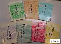
(1) Revised New Edition Cultural Properties Historic Sites, Historic Sites, Monuments in Chuo-ku 1995
(2) Cultural Properties of Chuo-ku Art, Crafts, ancient document, 1976
(3) Cultural Properties Bridge in Chuo-ku, published in 1977
(4) Cultural Property Tangible Folk Cultural Properties of Chuo-ku -Faith-Published in 1981
(5) Cultural Property Tangible Folk Cultural Properties of Chuo-ku-Tools-Published in 1984
(6) Cultural Property Tangible Folk Cultural Properties of Chuo-ku-ku-Tools 2-Published in 1987
(7) Cultural Properties Building in Chuo-ku, published in 1988
♪ Talking about the old days of Chuo-ku
This is a compilation of the contents of the cultural property round-table conference "Meeting about the Old Age", which has been held every year in various parts of the city since 1984. Mainly, people born and raised in Chuo-ku tell about old life and change of town mainly from the state of the town from the early Taisho era, memory of the Great Kanto Earthquake, life in elementary school, etc. . A total of 17 books. (Chuo-ku Board of Education, about 21cm, around 80 pages)
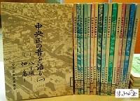
(1) Hatchobori and Tsukuda Island, which talks about the old days of Chuo-ku, published in 1989
(2) Higashinihombashi, Bakurocho, and Yokoyamacho, which talk about the old days of Chuo-ku, published in 1989
(3) Irifune, Minato, and Tsukishima, which talk about the old days of Chuo-ku
(4) Kyobashi Yaesu (2) and Kyobashi Daikon River Bank, which talk about the old days of Chuo-ku, published in 1991
(5) Published by Hamacho and Koamicho, which talks about the old days of Chuo-ku
(6) Muromachi, Honmachi, and Shinkawa 1999, which talk about the old days of Chuo-ku
(7) Akashicho, Tomizawa-cho, which talks about the old days of Chuo-ku
(8) Kobuna-cho, Shintomi Heisei 6, which talks about the old days of Chuo-ku
(9) Hakozaki-cho, Tsukiji, which talks about the old days of Chuo-ku
(10) Honishi-cho, Hisamatsu-cho, which talks about the old days of Chuo-ku
(11) Ningyocho and Horidome-cho, which talk about the old days of Chuo-ku
(Twelve) Otemmacho and Kakigaracho, which talk about the old days of Chuo-ku, published in 1998
(Thirteen) Kayabacho and Kodemmacho, which talk about the old days of Chuo-ku, published in 1999
(14) Kabuto-cho, Nihonbashi 2012, which talks about the old days of Chuo-ku
(15) Yaesu 1-chome, Nakashu 2001, which talks about the old days of Chuo-ku
(16) Kachidoki, Toyomi-cho, Harumi 14, which talks about the old days of Chuo-ku
(17) Ginza 2016, which talks about the old days of Chuo-ku
♪ Chuo-ku Cultural Properties Survey Report
This is a record and report based on a deep delve into each theme in Cultural Heritage, Chuo-ku. A total of 5 books. (Chuo-ku Board of Education)
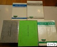
(Photos are in order from left in both upper and lower rows.)
Chuo-ku Cultural Properties Survey Report Vol. 1
Tsukiji's Foreign Housing-Survey Report on Polaba Bungalow, an attached foreign housing at St. Luke's International Hospital-Published 1992 (26cm, 118 pages).
Chuo-ku Cultural Properties Survey Report Vol. 2
Wooden buildings in Chuo-ku, published in 1993 (30cm, 154 pages)
Chuo-ku Cultural Properties Survey Report Vol. 3
Documents owned by the Old House of Chuo-ku-ku-Ozu Shoten, Sasagi In Store, Nakamura House Document-Published in 1995 (26cm, 195 pages)
Chuo-ku Cultural Properties Survey Report Vol. 4
Documents from Sugimori Shrine, published in Heisei 8 (30cm, 208 pages)
Chuo-ku Cultural Properties Survey Report Vol. 5
Bridge, Hashizume Plaza in Chuo-ku-ku-modern bridge survey-published in 1998 (30cm, 354 pages)
♪ Walk in Central Ward - Visit Historic Sites and History -
This book looks at Chuo-ku from the perspective of life, streets, Civilization and enlightenment, literature, etc., and introduces the footprints of Cultural Heritage and Chuo-ku in the ward. A total of 9 books. (Chuo-ku Planning Department Public Relations Section, 18cm tall, around 200 pages)
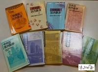
1st Collection Walk in Chuo Ward-Visit Historic Sites and History-Published in 1988
Vol. 2 Walk in Chuo Ward - Visit Historic Sites and History-Published in 1992
3rd Collection Walk in Chuo Ward-Visit Historic Sites and History-Published in 1995
4th Collection Walk in Chuo Ward-Visit Historic Sites and History-Published in 1998
5th Collection Walking in Chuo Ward - Visiting Historic Sites and History-Published in 2001
6th Collection Walking in Chuo Ward-Visit Historic Sites and History-Published in 2004
7th Collection Walking in Chuo Ward-Visit Historic Sites and History-Published in 2007
8th Collection Walk in Chuo Ward-Visit Historic Sites and History-Published in 2010
9th Collection Walking in Chuo Ward-Visit Historic Sites and History-Published in 2013
※ After applying to the Chuo Ward Kyobashi Library Regional Archives, we photographed a book.
Now, it is a book that you can realize how Chuo-ku, which we know, changes with the changing times, and that there is something that does not change only in Chuo-ku. I would like to use it for city walks and local research.
Correspondent Minato kid, Chuo-ku Tourism Association

No. 33 January 18, 2019
Ningyocho, Hamacho, Higashinihombashi area|
Tsukuda, Tsukishima, Kachidoki and Harumi areas|
Nihonbashi, Kyobashi and Yaesu areas|
History, culture|
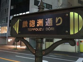
Tsukiji, Shintomi, Minato area|
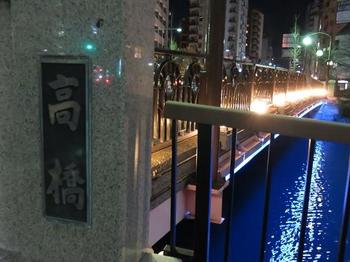
Kayabacho, Hatchobori, and Shinkawa areas|
Ginza area
Page top▲


