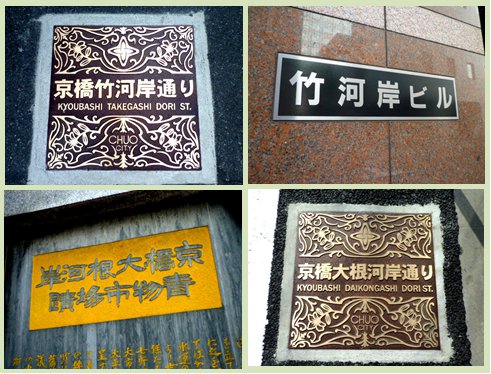
The road on the north side along the reclaimed Kyobashi River has recently been nicknamed the Chuo-ku Road, "Kyobashi Takekawa Bank Street" (upper photo) and "Kyobashi Daikon Bank Street" (lower photo). It is located across Chuo-dori, Kyobashi 3-chome, on the east side from the Police Museum to Showa-dori Street, and on the other side, on the Sotobori-dori St., is Daikon Riverside Street. As the name implies, each was a riverbank.
 During the Edo period, the riverbank was a cargo landing site for goods and served as a storage and storage facility. It is under the direct control of the Shogunate, and the townspeople seem to have used it by paying upfront money. Numerous riverbanks remain as historic sites in the ward, including the fish shore of Nihonbashi, the Shuuga shore, the west shore, and the Gyotoku riverbank. It can be seen that the current Chuo-ku was the center of boat transportation and the accumulation area.
The Kyobashi River has been reclaimed since the latter half of 1955 and has become a metropolitan high-speed company line. The northeast side is the "Bamboo Riverside", and the "Kyobashi Takegashi" of Hiroshige's "Hundred Views of Edo" is known. This is due to the fact that bamboo materials were transported from the suburbs of Edo. It is sketched that there was a bamboo wholesaler even in the Meiji period. At present, there is no impression at all, but the building called "Takegawa Riverside Building" seems to be trying to talk about the past.
The northwest side of the Kyobashi River is the Daikon Riverside, and now there are monuments to the birthplace of Edo Kabuki and the site of the Kyobashi Daikon Riverside Blue Market, which are easy to understand. In the early Edo period, selling vegetables and other items began around here, and eventually came to be called the radish riverbank, and it became a market. It was relocated to Tsukiji Market in 1935 after the Great Kanto Earthquake. @ Akira Makibuchi

