The mouth of the Sumida River, which flows into Tokyo Bay, is located in Chuo Ward.
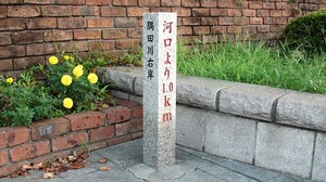
At the 1.0 km point of the Sumida River (approximately 23 km in length) starting from the estuary, the 1.0 km point is the Sumida River (approximately 23 km in length).
A sign (↓ photo) stands.

About Sumida River↓
"It was originally the main stream of Arakawa, but since the Arakawa Floodway was designated as Arakawa by a Cabinet Order in 1965, the downstream from Iwabuchi Sluice Gate was "Sumida River". Currently, it branches off with Arakawa at Shin-Iwabuchi Suimon (Kita-ku, Tokyo), joins tributaries such as the Kanda River, and flows into Tokyo Bay" (from the Arakawa Lower River Office website (HP), which is under the jurisdiction of the Ministry of Land, Infrastructure, Transport and Tourism) )
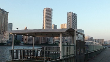
This place, 1.0 km from the mouth of the river, is the "Akashicho / St. Luke Garden Front" (↓ photo) of the water bus "Tokyo Mizube Line". By this water bus, you can go to Hamarikyu, Odaiba, Ryogoku and Asakusa.
Water bus "Tokyo Waterside Line" official website
http://www.tokyo-park.or.jp/waterbus/
I think it's fun to take a walk along the Sumida River based on sightseeing by water bus and the following information.
Sumida River Waterside Walking Course ↓ (From Chuo-ku Tourism Association website)
http://www.chuo-kanko.or.jp/walking/sumidagawa/01.html
Let's walk along the Sumida River! ↓ (From the Tokyo Metropolitan Construction Bureau website)
http://www.kensetsu.metro.tokyo.jp/sumidamap/

