Since Great East Japan Earthquake, I have been worried about the arrival of major earthquake centered on the Nankai Trough. I would like to consider the stratum of Chuo-ku based on the estimated seismic intensity in Tokyo during the Great Kanto Earthquake.
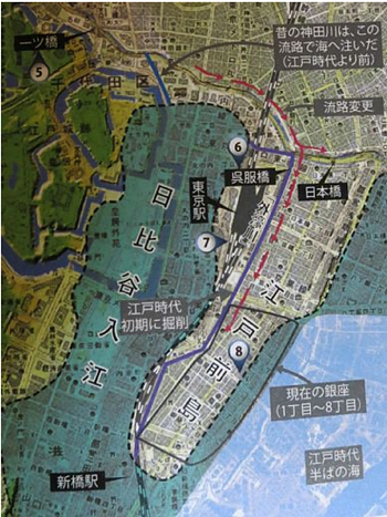
Edo, including Yamanote and Shimomachi, has a history of reclamation and moat construction. Immediately after the opening of Edo, the Nihonbashi and Ginza districts were created by reclaiming Edo Maejima from the Hongo Plateau, and the Hibiya Inlet was reclaimed to create the Samurai residence area in the Hibiya, Yurakucho and Marunouchi districts. During the Edo period, the Tsukishima and Harumi districts were seas.
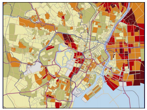
Let's take a look at the distribution of seismic intensity in Tokyo during the Great Kanto Earthquake. I'm worried about the red numbers (equivalent to seismic intensity 7) of Akasaka Tameike, Azabujuban and Koto-ku.
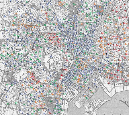
Tsukuda Island, which was not reclaimed and built, is a land created by naturally depositing sediment flowing from the upstream of the Sumida River, so the altitude is higher than the Tsukishima and Kachidoki districts. It seems that the seismic intensity at the time of the Great Kanto Earthquake was about 5. On the other hand, the Tsukishima, Kachidoki and Harumi districts, which are land reclaimed using dredged soil from the Sumida River, are said to have a seismic intensity of about 5 to 6 at the time of the Great Kanto Earthquake.
I had a preconception that the seismic intensity at the time of the Great Kanto Earthquake in the Tsukishima and Kachidoki districts might be larger because it was a landfill, but I was surprised that it was small about Ginza and Nihonbashi.
In today's Chuo-ku, there was a sandbar called Edo Maejima. On the west side, there was a Hibiya inlet from Hibiya to Otemachi. Immediately after the opening of the prefecture, the shogunate reclaimed it.
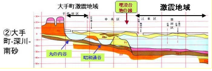
It is said that the ground is bad on the east side of the Sumida River and the ground on the west side is good. However, there is a severe seismic area on the Otemachi side because there is a hole in the flood area and alluvial ground enters there. On the other hand, the good ground of Edo Maejima is clear.
When purchasing real estate, look at the old map and check the terrain. Don't be danced only by the place name "It's safe if you're in the mountains, downtown is dangerous"! The Great Kanto Earthquake occurred on September 1, 2011.
Reference: Masayuki Takemura (2003): Central Tokyo (formerly 15 wards) caused by the Kanto Earthquake of 923 Detailed seismic intensity distribution and surface ground structure, "A Collection of Papers on the Japan Association for Earthquake Engineering," Japan Association for Earthquake Engineering, Vol. 3, No. 1

