Everyone knows that the Kaede River and Tsukiji River have been reclaimed and have become the capital high speed, but in 1930, a new canal was opened between the Kaede River and the Tsukiji River as a reconstruction project after the earthquake. I think many people did not know that it was reclaimed in Showa 35 30 years later and reborn as an expressway. Actually, I didn't know until I became a correspondent of the Chuo-ku Tourism Association.
This time, we are planning to walk along the ruins of the Kaede River and Tsukiji River.
It is a canal between the current Ginza 1-chome and Shintomicho 2-chome, and this canal connects Nihonbashi and Tsukiji by waterway. Shinkin Bridge, Shintomi Bridge and Miyoshi Bridge were bridged.
The start was to go south from the vicinity of Danjo Bridge in Kaede River and aim for Miyoshi Bridge.


The photo on the left shows a photo taken downstream from Danjo Bridge, that is, toward Shinkin Bridge. We aim for Shinkin Bridge on the right bank of the Kaede River site.
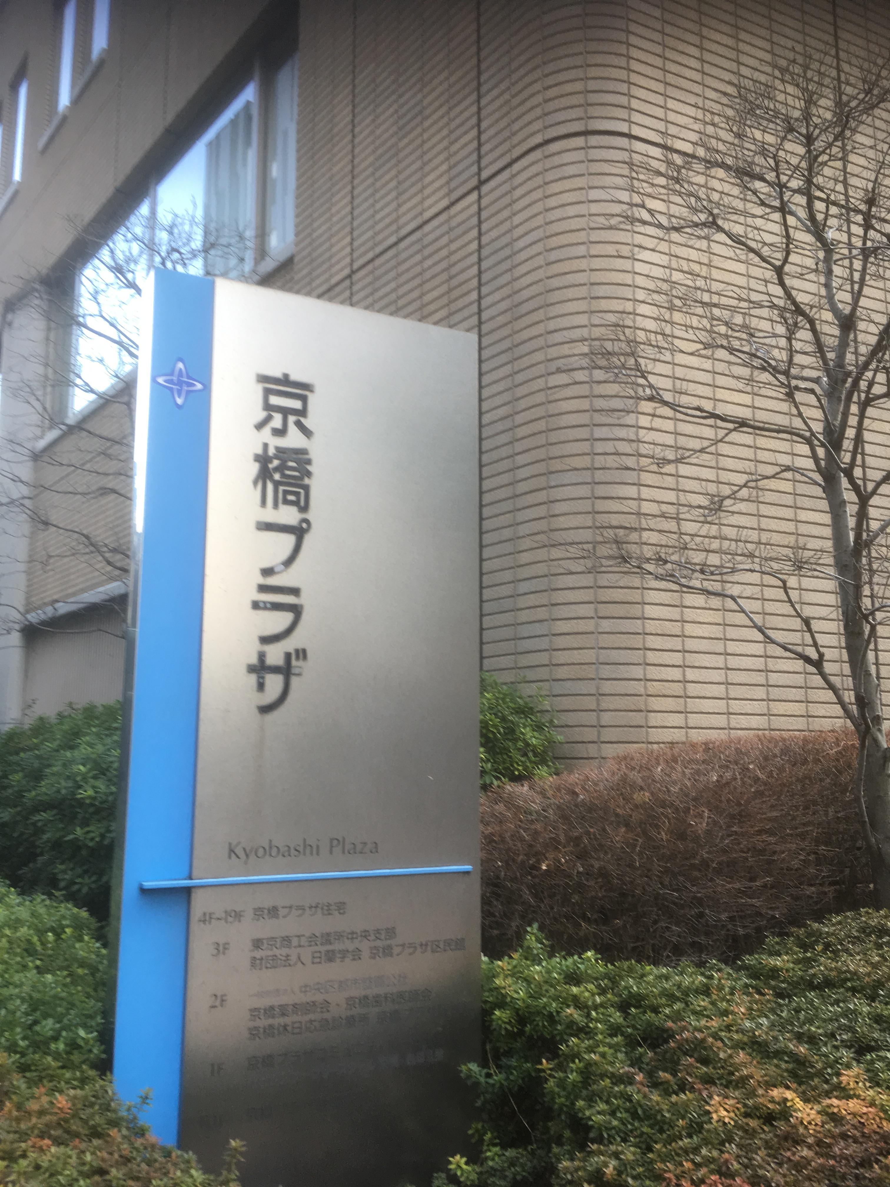

We have seen Kyobashi Plaza, a sacred place. The Chuo-ku Tourism Association Secretariat is located on the third floor of this building. In the planting of Kyobashi Plaza, there is an explanation board about the origin of Kibiki-cho. It is said that the stone in the enclosure of the signboard uses stones excavated from the ground.


In addition, there is an explanation board for the Iri Riverbank in this Kyobashi Park. In these two explanations, it curves from Kaede River and leads to Sanjumabori. There is no mistake because it is an information board about the Edo period, but this project is to walk on the ruins of a canal that was excavated at the end of Mitsuhashi in 1930 and divided into the Tsukiji River. Then the park was filled with white placards. What is it? As I approached, it was a placard for tomorrow's Tokyo Marathon. That's right, I've got a point in myself.
Let's go to the Shirokane Bridge. Then I found another sign.

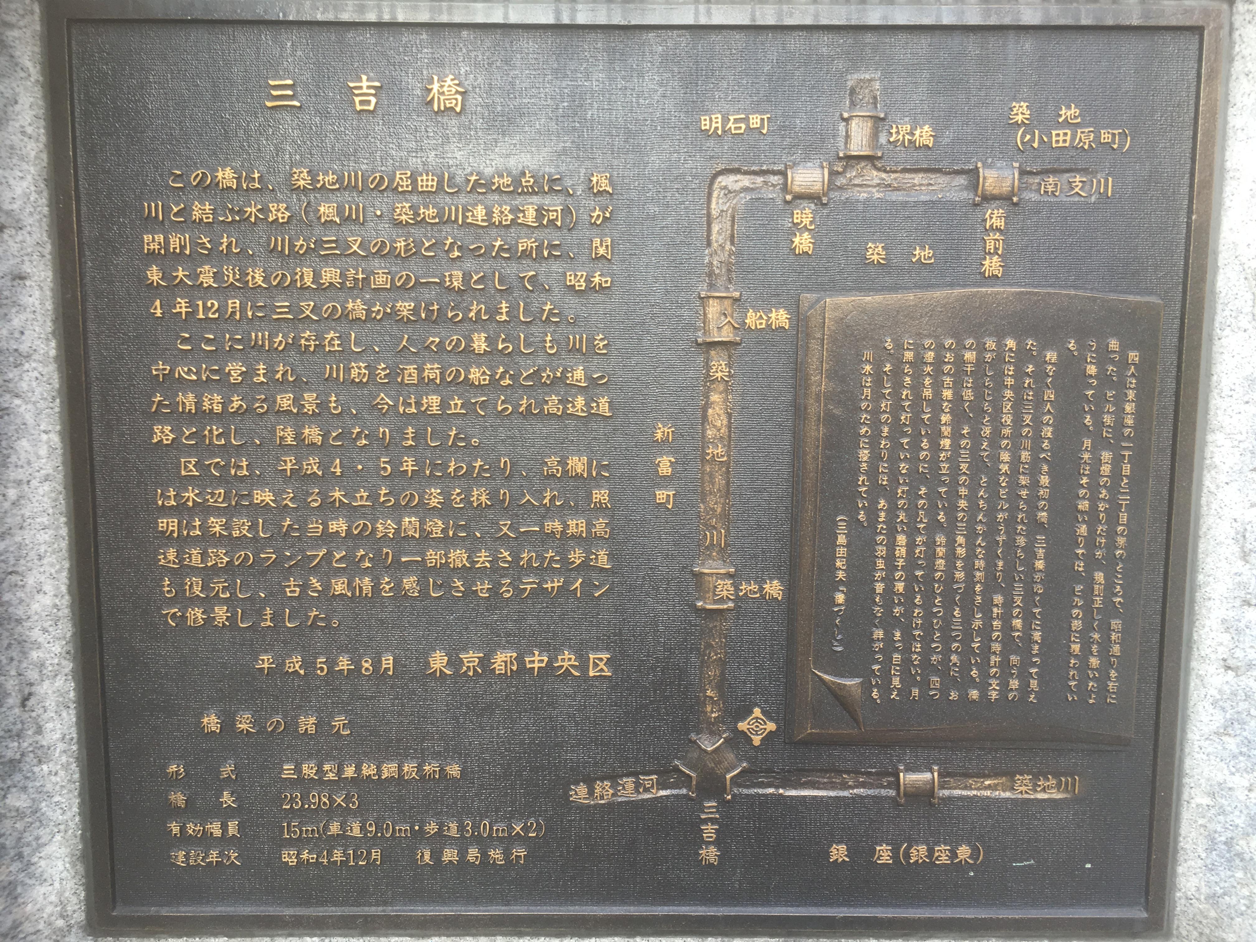
This is an explanation of Mitsuhashi ruins.


We arrived at the New Gold Bridge. Shinkinbashi has the entrance of Kyobashi, the capital high school. The photo on the right shows the direction from Shinkin Bridge to Shintomi Bridge. It is said that the name of the bridge was Shinkinbashi to connect Shin-Tomicho and Kin Rokucho. The name of Shinkinbashi was left at the upper part of the left bank, but a children's amusement park, and at the intersection, although small.


Then, follow Shinkin Bridge and proceed to Shintomi Bridge on the left bank of the Kaede River and Tsukiji River Canal Ruins.


There was a small shrine on the left bank of the ruins of the Kaede and Tsukiji River Canals. When I checked the name, it was "Shintomi Reconstruction Inari Shrine". I've been around this area several times before, so I knew the existence of this shrine ...
From the word reconstruction, it seems to have been built after the earthquake, and I only knew that it was a bigger shrine with a torii gate several meters away before. In addition, there was a five-story stone pagoda behind the shrine of the shrine. Is this also on the premises of the shrine? I'm a little worried that the ring part was broken.


That's Shintomi Bridge. The name of Shintomi Bridge remained at the park and intersection.


If you think I saw it somewhere in the Japanese house shown in the photo on the right, it was "Onoya Sohonten" in the country registration Tangible Cultural Property. It is a townhouse architecture in the Taisho era.


The photo on the right is a picture of Miyoshi Bridge from Shintomi Bridge.
From Shintomi Bridge, proceed to Miyoshi Bridge on the right bank of the Kaede and Tsukiji River connecting canals.


There was "Suzuki Building" which was certified by Historic buildings in Tokyo. Certainly, I felt that there were a variety of horseshoe-shaped and round-shaped windows.


I arrived at Miyoshi Bridge, the end of this city walk. The brown building that rises behind Miyoshi Bridge is Chuo-ku Office. The photo on the right shows the direction of Shintomibashi from Miyoshi Bridge.
And there is an explanation board of Miyoshi Bridge in the upper part of the right bank. On the explanation board, Ippen of Yukio Mishima's "Hashizukushi" is quoted. I have never read this novel, but it seems that the point is that this Miyoshi Bridge is a Mitamata Bridge.
Personally, I feel that this Miyoshi Bridge can attract more attention.


In Chuo-ku, renovation work was carried out in 1995, and Suzuran Lights at the time of construction were incorporated into lighting fixtures. In the photo on the right, you can see the letter "December 1929 Reconstruction Bureau Building XX".
Before this city walk, why did this canal have been excavated and had to be buried again in just 30 years? I was wondering. I checked it myself, but Tokyo was also renewed due to the "Teito Reconstruction Project" after the Great Kanto Earthquake. Most of the roads, bridges, rivers, etc. are still in use today. However, there are some items whose plans have been changed again due to post-war reconstruction and highway construction for the Tokyo Olympics.
The Kaede River and Tsukiji River Canals were newly excavated as a reconstruction project after the earthquake, and were very active in logistics from the Central Wholesale Market, which was relocated to Tsukiji after the earthquake. But has it been possible to stop the automobile after the war?
Reference: Map Dictionary of the River (Edo, 23 wards of Tokyo) by Kenji Sugawara
"News from Local Room" No. 152 No. 156 edited and published Chuo Ward Kyobashi Library

