Chuo-ku Tourism Association Official Blog

Chuo-ku Tourism Association correspondent blog

Introducing Chuo-ku's seasonal information by sightseeing volunteer members who passed the Chuo-ku Tourism Association's Chuo-ku Tourism Certification and registered as correspondents.

List of Authors

>>About this blog

Recent blog post

There was a beach in Tsukishima.

[yaz] August 10, 2018 12:00

This is the last blog on the theme of the Tsukishima area. About 100 years ago, there was a beach at the waterfront "Tsukishima district" in Tokyo. In the Meiji era, the sea bathing trend was triggered by Jun Matsumoto (Ryojun), the Army Army Medical Supervisor, who encouraged sea bathing for medical care and recreation.

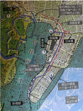
The Omori Beach was opened in 1891, the Anamori Beach was opened in Meiji 35 (1902), and the Haneda Beach was opened in Meiji 42 (1909). It is said that sand baths became popular and were very popular. In the Taisho era, the beach spread across the city center to the Tsukishima and Fukagawa districts, and was opened along with the landfill of No. 3 (Kachidoki 5-6 chome) completed in 1913. At the beach, restaurants, accommodations and sea houses were developed and prospered greatly. On the map below, you can see a beach on the left (west side) of (No. 3).

Looking at the photos showing the sea bathing, there are many people in "loindoshi" that can not be considered from now on.

Tsukishima Beach (next to No. 3 landfill).jpg Tsukishima Beach. jpg

In the 1930s (1930)s, "baths" began to decline. This is due to landfill and seawater pollution.

After World War II, a period of high economic growth was reached, and beaches were not revived in Tokyo. Tsukishima is the same. Today's sea in Tokyo is unsuitable for sea bathing, but artificial beaches and hydrophilic revetments are being improved, and as water quality improves, it is expected that the liveliness will be restored again in the future. Expectations have been sent.

Reference:

1. 2005, Nihon University Faculty of Science and Engineering, "Study on the Transition of Leisure Culture at Waterfront in Tokyo"

2. Chuo-ku History Chart (Tsukishima edition)


Considering seismic intensity during the Great Kanto Earthquake

[yaz] August 8, 2018 14:00

Since Great East Japan Earthquake, I have been worried about the arrival of major earthquake, mainly in the Nankai Trough. I would like to consider the stratum of Chuo-ku based on the estimated seismic intensity in Tokyo during the Great Kanto Earthquake.

Edo, including Yamanote and Shitamachi, has a history of reclamation and moat creation. Immediately after the opening of Edo, the Nihonbashi and Ginza districts were created by the landfill of Edo Maejima, which continued from the Hongo Plateau, and the Hibiya Inlet was reclaimed to create the Samurai residence area of Hibiya, Yurakucho and Marunouchi districts. In the Edo period, the Tsukishima and Harumi districts were seas.

Let's take a look at the seismic intensity distribution of Tokyo Prefecture during the Great Kanto Earthquake. I'm worried about the red numbers (equivalent to seismic intensity 7) of Akasaka Tameike, Azabujuban and Koto-ku.

Seismic intensity distribution in Tokyo during the Great Kanto Earthquake. pngSeismic intensity distribution in Tokyo Prefecture (Great Kanto Earthquake).png

Tsukuda Island, which was not reclaimed and created, is a land created by naturally depositing sediment flowing from the upstream of the Sumida River, so the altitude is higher than the Tsukishima and Kachidoki districts. It seems that the seismic intensity at the time of the Great Kanto Earthquake was about 5. On the other hand, the Tsukishima, Kachidoki, and Harumi districts, which are land reclaimed using soil dredged on the Sumida River, are said to have had a seismic intensity of about 5-6 during the Great Kanto Earthquake.

Because it was a landfill, I had a preconception that the seismic intensity at the time of the Great Kanto Earthquake in the Tsukishima and Kachidoki districts might be even larger, but I am surprised at the size of Ginza and Nihonbashi.

There was a reef called Edo Maejima in Chuo-ku today. On the west side, there was Hibiya inlet from Hibiya to Otemachi. Immediately after the opening of the prefecture, the Shogunate reclaimed the land.

Edomejima, Hibiya Irie. png

It is said that the ground on the east side of the Sumida River is bad and the ground on the west side is good. However, there is a hole in the flood area, and alluvial ground enters there, so there is a severe seismic area on the Otemachi side. On the other hand, the good ground of Edo Maejima is clear.

East-West fault (Chuo-ku to Koto-ku).png

If you buy real estate, look at the old map and check the terrain. Don't be danced only by the place name "Safe in the mountains, downtown is dangerous"! The date of the Great Kanto Earthquake = September 1 was a word.


1