
Kakigara Town and River Steamship

The photo above is a model of a steamboat called Toun Maru, which was active from the Meiji era to the early Showa era (taken at the Logistics Museum). It seems to have been called river steam or river steamboat.
As the name implies, Tokyo Bay Kisen (currently Tokai Kisen) supported shipping mainly to Tokyo Bay and Izu-Oshima Island, while domestic transportation (currently Nippon Transportation), which operated the Toll Maru, supported inland water transportation near Tokyo, centered on the Tone River.
In addition, just as Tokyo Bay Kisen repeated dead heat with local capital shipping companies such as Awa Kyoritsu Kisen, domestic transportation also competes with Choshi Kisen and Kinoshita's large capitalist Yoshioka family. It has a history of turbulence of alliance and alliance.
※The transportation circle existed from No. 1 to No. 56 in a serial number, and there were a mixture of outer ring ship type and screw type, but here I will write `` transportation circle '' without distinction .
River steamship route
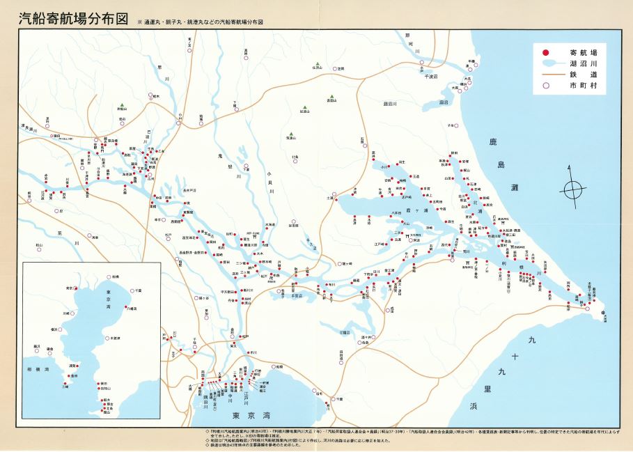
Anyway, what surprises me is the size of the river steamship route and a huge number of destinations. The map image above links the pdf file, so please enlarge it by all means. (This is an appendix map of "Modern on the River" described later.)
I knew somehow that there was a route connecting the Tone River and the Edo River in the past, but it was not like such a single route, but the east covered the coast of Kitaura and Kasumigaura, and the west was Kinugawa It seems that it covered a part and the basin of the Watarase River. And there was also a major terminal in Kakigara-cho, Nihonbashi-ku.
The total length of the transportation circle seems to have been more than 20m, although there are individual differences. The width of the ship is just over 3m. There is a record that the capacity was or that a passenger ship carried around 50 passengers. I'm a little impressed when I think that a steamboat of that size was going back and forth in the river near Tokyo in all directions. 。
Kakigaracho Terminal

The first terminal on the Tokyo side of domestic transportation (which seems to have been called the nuclear power plant) was Ogibashi along the Onagi River, but then Takahashi on the Onagi River, Ryogoku along the Sumida River, and Kakigara along the Hakozaki River. Town became the nuclear power plant.
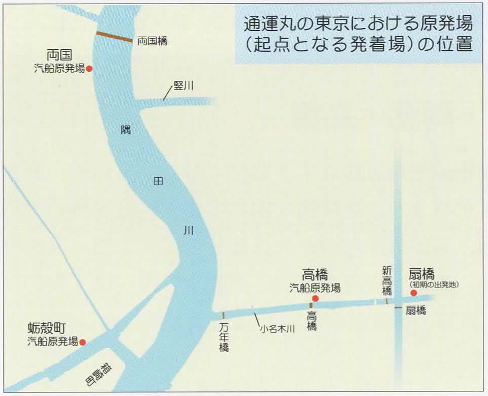
The current Kakigara town does not face the river at all, but at that time (or until 1971 when the capital city and TCAT could be established), there was a fine river (canal) called "Hakozaki River", and along that river Kakigara It seems that there was a nuclear power plant.
By the way, the Hakozaki River seems to have existed since the Edo period (the location is around the current "Muse Yozo Hamaguchi Yamasa Collection"), but the location of the nuclear power plant is slightly upstream, north of Tosa Bridge (at that time), and it seems to have been around the eastern wall of the current Royal Park Hotel.
It's interesting to see the Tokyo City Air Terminal (TCAT) instead of the Kakigaracho Terminal when you stand around and turn toward the old Hakozaki River.
The Hakozaki River itself has disappeared, but you still keep the name in the names of the parks called "Hakozaki River Daiichi Park" and "Hakozaki River Daini Park". (The source of the above photo and the map on the left are also from "Modern on the River").
Model of Transportation Maru

As I have referred to many times in the description so far, there is no more material about the transportation Maru, "Illustration: Modern on the River-Toun Maru and the History of River Steamship in Kanto-". There is a book that seems to be It is a wonderful book full of valuable images and statistical materials in A4 size, about 200 pages.
It's a pity that it was not sold at bookstores because it was produced as a commentary catalog for the 2007 exhibition, but I happened to be able to buy it at the Logistics Museum. Perhaps there is still a possibility that the Nakagawa Funabansho Museum in Koto-ku, which jointly held the exhibition at that time, and the Yoshioka Machikado Museum (Kinoshita) still have stock, but it has not been confirmed.
-----
Anyway, this book has an interesting page called "Model of an outer ring steamboat", where photos of the "Yun Maru Model" held in many museums including the Logistics Museum are posted.
According to the commentary, the engineer at Ishikawajima Heavy Industries (at that time) created an estimated restoration map of the first transportation Maru in 1962, behind the Ishikawajima Plain Shipyard, which really built the first transportation Maru in the first place. Based on the drawings, first, the backward of domestic transportation, Nippon Express made a model (the photo at the beginning of this article). After that, museums around the country were produced one after another based on the same drawings.
The transportation circle model on the right is a photograph of the exhibits of the Chiba Prefectural Seki-juku Castle Museum, but it is certainly two melons.
It is too high for amateurs like me to make a full-fledged model of transportation Maru based on the drawings, but for such me, paper crafts were prepared at the Logistics Museum (^^^). Just replacing the seal is an excellent thing that can be both a transportation Maru and a Choko Maru (built by the Yoshioka family). (lower right)
But. The more you read how to make it, the more difficult the process of making it, and it still remains untouched. 。 。 (laughs)
Yasuji Inoue's work also

Yasuji Inoue's work, which I introduced earlier, also depicted the area near Kakigaracho departure point.
The figure of the riverbank of Kakigara-cho (1881). (The source above is public domain)
The first Toun Maru started operation in 1877 (Meiji 10), so it has been only four years since then. The transportation Maru on the right is probably early, and from the point of view of the ship, I feel like I'm about to arrive at Kakigara-cho or heading to Ryogoku nuclear power plant.
A little strange is the direction of the shadow of the rickshaw and the person pulling it. According to the feeling of the picture, it is dusk, and even if you search on the net, there are also hits that are described as "scenery of dusk". But if that shadow is real, it means that the light is shining from the east (the river) ...?
Also, it seems that the river width looks very wide because it is the Sumida River, not the Hakozaki River. There should be Nakasu area on the north side of Hakozaki, but it was in 1886 that Nakasu was reclaimed. In 1881, when this picture was drawn, the north side of Hakozaki seemed to be a river surface or a wetland full of reeds. A little north of Kakigaracho Terminal, Old: You may have seen such a scenery from around the iris shore.